Chapel en le Frith night lights from space
Night Light of Chapel en le Frith (England) from space (United Kingdom) Src. Average luminocity for 10x10km area is 3.1187% and for 50x50km: 17.3827%.
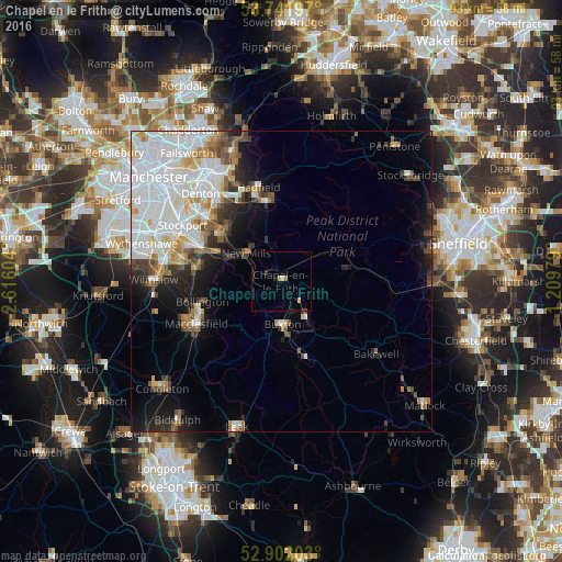
Analysis of Chapel en le Frith night lights 2016
Square area 10x10 km:
 0%
0%90-99
0%80-89
0.51%70-79
1.01%60-69
0.13%50-59
0.38%40-49
0.25%30-39
0.76%20-29
0.63%10-19
1.26%0-9
95.08%Square area 50x50 km:
6.47%90-99
3.78%80-89
1.48%70-79
1.44%60-69
1.26%50-59
1.46%40-49
1.66%30-39
1.49%20-29
2.43%10-19
5.37%0-9
73.16%Clear (daylight) street map image can be seen on geolist.org.
Map coordinates:
53° 44' 31.1" North, 2° 36' 57.7" West
53° 19' 26.7" North, 1° 54' 46.5" West
52° 54' 7.3" North, 1° 12' 35.2" West
Some cities around Chapel en le Frith sort by population:
• High Peak
6.6 km =4.1 mi,  42°
42°
• Glossop
13.5 km =8.4 mi,  349°
349°
• Buxton
7.4 km =4.6 mi,  178°
178°
• Marple
12.7 km =7.9 mi,  308°
308°
• New Mills
7.4 km =4.6 mi, 308°
• Poynton
13.8 km =8.6 mi,  282°
282°
• Bollington
13.5 km =8.4 mi,  255°
255°
• Whaley Bridge
4.7 km =2.9 mi, 278°
2653368 (p: 6,598)
Sources (retrieved 2019-11-25):
» Earth at Night: Flat Maps 2012, 2016