Poynton night lights from space
Night Light of Poynton (England) from space (United Kingdom) Src. Average luminocity for 10x10km area is 37.2315% and for 50x50km: 28.3848%.
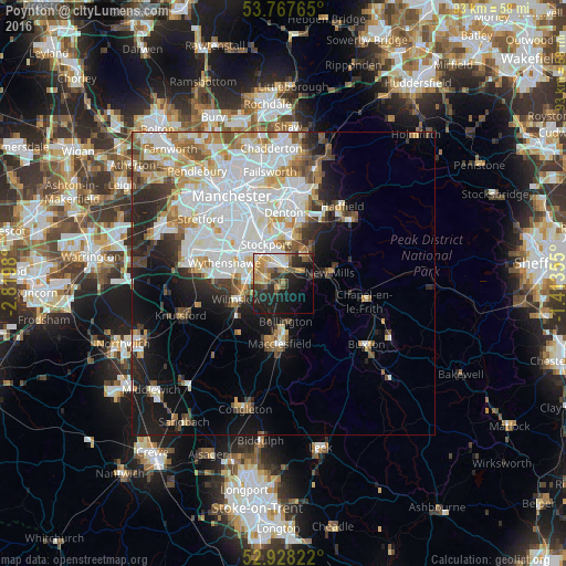
Analysis of Poynton night lights 2016
Square area 10x10 km:
 4.23%
4.23%90-99
4.1%80-89
4.89%70-79
8.73%60-69
5.29%50-59
5.56%40-49
3.84%30-39
5.95%20-29
15.34%10-19
25.93%0-9
16.14%Square area 50x50 km:
9.04%90-99
6.59%80-89
2.79%70-79
2.9%60-69
2.82%50-59
2.51%40-49
2.67%30-39
2.75%20-29
4.56%10-19
8.74%0-9
54.63%Clear (daylight) street map image can be seen on geolist.org.
Map coordinates:
53° 46' 3.5" North, 2° 49' 11.3" West
53° 21' 0" North, 2° 7' 0" West
52° 55' 41.6" North, 1° 24' 48.8" West
Some cities around Poynton sort by population:
• Stockport
7.2 km =4.5 mi,  337°
337°
• Cheadle Hulme
5.6 km =3.5 mi,  300°
300°
• Bramhall
3.4 km =2.1 mi,  285°
285°
• Marple
6.1 km =3.8 mi,  35°
35°
• New Mills
8 km =5 mi,  77°
77°
• Hazel Grove
3.7 km =2.3 mi,  0°
0°
• Bredbury
7.4 km =4.6 mi, 0°
• Bollington
6.2 km =3.9 mi,  175°
175°
2639941 (p: 14,351)
Sources (retrieved 2019-11-25):
» Earth at Night: Flat Maps 2012, 2016