Whaley Bridge night lights from space
Night Light of Whaley Bridge (England) from space (United Kingdom) Src. Average luminocity for 10x10km area is 4.3737% and for 50x50km: 21.3094%.
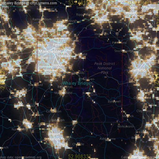
Analysis of Whaley Bridge night lights 2016
Square area 10x10 km:
 0%
0%90-99
0%80-89
0.25%70-79
1.01%60-69
0%50-59
0.38%40-49
0.88%30-39
1.89%20-29
3.28%10-19
3.28%0-9
89.02%Square area 50x50 km:
8.03%90-99
5.29%80-89
1.99%70-79
1.85%60-69
1.51%50-59
1.62%40-49
1.58%30-39
1.59%20-29
2.48%10-19
5.01%0-9
69.07%Clear (daylight) street map image can be seen on geolist.org.
Map coordinates:
53° 44' 53.3" North, 2° 41' 8.6" West
53° 19' 49.1" North, 1° 58' 57.4" West
52° 54' 30" North, 1° 16' 46.1" West
Some cities around Whaley Bridge sort by population:
• High Peak
10 km =6.2 mi,  65°
65°
• Buxton
9.4 km =5.8 mi,  149°
149°
• Marple
8.9 km =5.5 mi,  323°
323°
• New Mills
4.1 km =2.5 mi,  343°
343°
• Hazel Grove
10.7 km =6.6 mi,  303°
303°
• Poynton
9.2 km =5.7 mi,  283°
283°
• Bollington
9.3 km =5.8 mi,  244°
244°
• Chapel en le Frith
4.7 km =2.9 mi,  98°
98°
2634194 (p: 5,140)
Sources (retrieved 2019-11-25):
» Earth at Night: Flat Maps 2012, 2016