Caerleon night lights from space
Night Light of Caerleon (Wales) from space (United Kingdom) Src. Average luminocity for 10x10km area is 50.6524% and for 50x50km: 20.8765%.
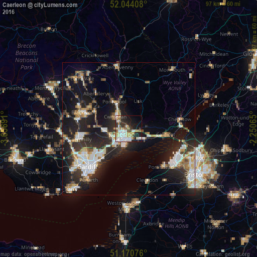
Analysis of Caerleon night lights 2016
Square area 10x10 km:
 12.83%
90-99
14.44%80-89
4.81%70-79
7.35%60-69
3.34%50-59
3.61%40-49
3.74%30-39
6.82%20-29
11.9%10-19
19.79%0-9
11.36%Square area 50x50 km:
3.7%90-99
4.38%80-89
1.64%70-79
2.18%60-69
2.04%50-59
2.39%40-49
2.36%30-39
3.1%20-29
8.14%10-19
15.19%0-9
54.87%Clear (daylight) street map image can be seen on geolist.org.
Map coordinates:
52° 2' 38.7" North, 3° 39' 24.9" West
51° 36' 34.3" North, 2° 57' 13.6" West
51° 10' 14.7" North, 2° 15' 2.3" West
Some cities around Caerleon sort by population:
• Newport
3.9 km =2.4 mi,  231°
231°
• Cwmbran
6.9 km =4.3 mi,  316°
316°
• Pontypool
12 km =7.5 mi,  328°
328°
• Risca
10.2 km =6.3 mi,  269°
269°
• Caldicot
13.8 km =8.6 mi,  100°
100°
• Abercarn
13.2 km =8.2 mi,  288°
288°
• Magor
9.1 km =5.7 mi,  111°
111°
• Undy
10.3 km =6.4 mi, 111°
2654093 (p: 8,747)
Sources (retrieved 2019-11-25):
» Earth at Night: Flat Maps 2012, 2016