Burry Port night lights from space
Night Light of Burry Port (Wales) from space (United Kingdom) Src. Average luminocity for 10x10km area is 3.5112% and for 50x50km: 4.7396%.
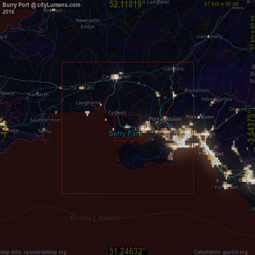
Analysis of Burry Port night lights 2016
Square area 10x10 km:
 0%
0%90-99
0%80-89
0.28%70-79
0.56%60-69
0%50-59
0.84%40-49
1.12%30-39
0%20-29
2.8%10-19
0.56%0-9
93.84%Square area 50x50 km:
0.61%90-99
0.79%80-89
0.34%70-79
0.53%60-69
0.76%50-59
0.62%40-49
0.71%30-39
0.7%20-29
1.58%10-19
3.29%0-9
90.06%Clear (daylight) street map image can be seen on geolist.org.
Map coordinates:
52° 7' 5.5" North, 4° 57' 0" West
51° 41' 3.7" North, 4° 14' 48.7" West
51° 14' 46.8" North, 3° 32' 37.5" West
Some cities around Burry Port sort by population:
• Swansea
22.1 km =13.7 mi,  108°
108°
• Llanelli
5.9 km =3.7 mi,  92°
92°
• Ammanford
21.5 km =13.4 mi,  55°
55°
• Gorseinon
14.2 km =8.8 mi,  96°
96°
• Clydach
23.9 km =14.9 mi, 90°
• Carmarthen
19.5 km =12.1 mi,  348°
348°
• Pontarddulais
14.7 km =9.1 mi,  76°
76°
• Brynamman
29.2 km =18.1 mi, 63°
2654229 (p: 8,310)
Sources (retrieved 2019-11-25):
» Earth at Night: Flat Maps 2012, 2016