Carmarthen night lights from space
Night Light of Carmarthen (Wales) from space (United Kingdom) Src. Average luminocity for 10x10km area is 7.8182% and for 50x50km: 2.8878%.
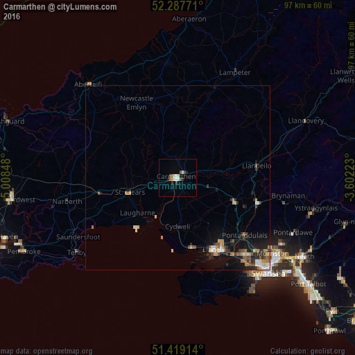
Analysis of Carmarthen night lights 2016
Square area 10x10 km:
 1.14%
1.14%90-99
1.64%80-89
0.76%70-79
0.51%60-69
0.51%50-59
1.14%40-49
1.77%30-39
1.01%20-29
0.51%10-19
0.63%0-9
90.4%Square area 50x50 km:
0.27%90-99
0.44%80-89
0.25%70-79
0.39%60-69
0.49%50-59
0.38%40-49
0.44%30-39
0.43%20-29
0.86%10-19
2.01%0-9
94.03%Clear (daylight) street map image can be seen on geolist.org.
Map coordinates:
52° 17' 15.8" North, 5° 0' 30.5" West
51° 51' 19.9" North, 4° 18' 19.3" West
51° 25' 8.9" North, 3° 36' 8" West
Some cities around Carmarthen sort by population:
• Llanelli
21.7 km =13.5 mi,  152°
152°
• Ammanford
22.9 km =14.2 mi,  107°
107°
• Gorseinon
27.5 km =17.1 mi,  138°
138°
• Clydach
33.8 km =21 mi,  124°
124°
• Pontarddulais
24.2 km =15 mi,  130°
130°
• Burry Port
19.5 km =12.1 mi,  168°
168°
• Brynamman
30.8 km =19.1 mi,  101°
101°
• Cardigan
35.2 km =21.9 mi,  316°
316°
2653755 (p: 15,854)
Sources (retrieved 2019-11-25):
» Earth at Night: Flat Maps 2012, 2016