Burley in Wharfedale night lights from space
Night Light of Burley in Wharfedale (England) from space (United Kingdom) Src. Average luminocity for 10x10km area is 25.1852% and for 50x50km: 26.1454%.
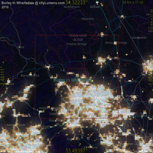
Analysis of Burley in Wharfedale night lights 2016
Square area 10x10 km:
 3.04%
3.04%90-99
2.38%80-89
3.84%70-79
2.38%60-69
1.72%50-59
3.44%40-49
3.57%30-39
5.16%20-29
13.76%10-19
23.41%0-9
37.3%Square area 50x50 km:
7.44%90-99
6.39%80-89
2.17%70-79
2.82%60-69
3.37%50-59
3.21%40-49
2.79%30-39
2.64%20-29
3.2%10-19
6.38%0-9
59.59%Clear (daylight) street map image can be seen on geolist.org.
Map coordinates:
54° 19' 20.4" North, 2° 27' 40" West
53° 54' 36.7" North, 1° 45' 28.7" West
53° 29' 38.3" North, 1° 3' 17.5" West
Some cities around Burley in Wharfedale sort by population:
• Keighley
10.8 km =6.7 mi,  244°
244°
• Yeadon
6.9 km =4.3 mi,  137°
137°
• Shipley
8.6 km =5.3 mi,  183°
183°
• Guiseley
4.9 km =3 mi, 142°
• Bingley
8.6 km =5.3 mi,  217°
217°
• Baildon
7.3 km =4.5 mi,  195°
195°
• Ilkley
4.6 km =2.9 mi,  290°
290°
• Otley
4.2 km =2.6 mi,  97°
97°
2654285 (p: 5,996)
Sources (retrieved 2019-11-25):
» Earth at Night: Flat Maps 2012, 2016