Bethnal Green night lights from space
Night Light of Bethnal Green (England) from space (United Kingdom) Src. Average luminocity for 10x10km area is 99.9759% and for 50x50km: 68.8878%.
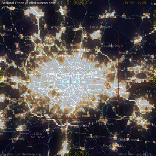
Analysis of Bethnal Green night lights 2016
Square area 10x10 km:
 98.26%
90-99
1.74%80-89
0%70-79
0%60-69
0%50-59
0%40-49
0%30-39
0%20-29
0%10-19
0%0-9
0%Square area 50x50 km:
28.34%90-99
16.82%80-89
6.73%70-79
5.41%60-69
6.6%50-59
6.24%40-49
5.09%30-39
5.28%20-29
6.61%10-19
6.02%0-9
6.84%Clear (daylight) street map image can be seen on geolist.org.
Map coordinates:
51° 57' 45.1" North, 0° 45' 51.2" West
51° 31' 37.8" North, 0° 3' 39.9" West
51° 5' 15.5" North, 0° 38' 31.3" East
Some cities around Bethnal Green sort by population:
• London
4.9 km =3 mi,  245°
245°
• Islington
3.1 km =1.9 mi,  289°
289°
• Canary Wharf
3.7 km =2.3 mi,  131°
131°
• Peckham
5.9 km =3.7 mi,  185°
185°
• Holloway
5.2 km =3.2 mi,  302°
302°
• Barnsbury
4.1 km =2.5 mi, 291°
• City of London
2.7 km =1.7 mi,  233°
233°
• Lambeth
4.9 km =3 mi, 225°
6690989 (p: 17,590)
Sources (retrieved 2019-11-25):
» Earth at Night: Flat Maps 2012, 2016