Bayston Hill night lights from space
Night Light of Bayston Hill (England) from space (United Kingdom) Src. Average luminocity for 10x10km area is 14.3122% and for 50x50km: 4.4911%.
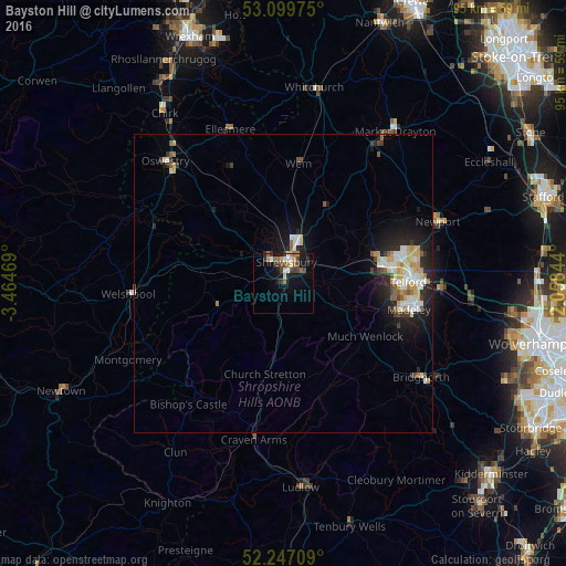
Analysis of Bayston Hill night lights 2016
Square area 10x10 km:
 1.32%
1.32%90-99
2.51%80-89
0.66%70-79
2.12%60-69
1.46%50-59
2.25%40-49
2.91%30-39
3.44%20-29
2.25%10-19
9.52%0-9
71.56%Square area 50x50 km:
0.63%90-99
0.95%80-89
0.56%70-79
0.58%60-69
0.36%50-59
0.51%40-49
0.41%30-39
0.61%20-29
1.23%10-19
3.12%0-9
91.04%Clear (daylight) street map image can be seen on geolist.org.
Map coordinates:
53° 5' 59.1" North, 3° 27' 52.9" West
52° 40' 31.8" North, 2° 45' 41.6" West
52° 14' 49.5" North, 2° 3' 30.4" West
Some cities around Bayston Hill sort by population:
• Telford
21.1 km =13.1 mi,  89°
89°
• Shrewsbury
3.9 km =2.4 mi,  9°
9°
• Wellington
16.7 km =10.4 mi,  80°
80°
• Hadley
18.9 km =11.7 mi, 81°
• Oakengates
21.1 km =13.1 mi, 84°
• Welshpool
26.1 km =16.2 mi,  266°
266°
• Wem
20.5 km =12.7 mi, 8°
• Broseley
20 km =12.4 mi,  110°
110°
2656129 (p: 5,079)
Sources (retrieved 2019-11-25):
» Earth at Night: Flat Maps 2012, 2016