Andover night lights from space
Night Light of Andover (England) from space (United Kingdom) Src. Average luminocity for 10x10km area is 14.0952% and for 50x50km: 4.623%.
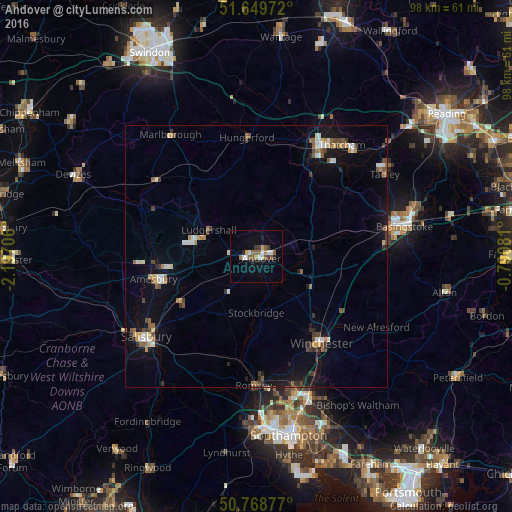

Analysis of Andover night lights 2016
Square area 10x10 km:
 2.1%
2.1%90-99
2.38%80-89
0.14%70-79
1.26%60-69
2.1%50-59
4.34%40-49
0.28%30-39
1.96%20-29
1.82%10-19
3.64%0-9
79.97%Square area 50x50 km:
0.44%90-99
0.73%80-89
0.31%70-79
0.45%60-69
0.58%50-59
0.77%40-49
0.62%30-39
0.72%20-29
0.54%10-19
2.97%0-9
91.87%Clear (daylight) street map image can be seen on geolist.org.
Map coordinates:
51° 38' 59" North, 2° 11' 49.4" West
51° 12' 40.9" North, 1° 29' 38.1" West
50° 46' 7.6" North, 0° 47' 26.9" West
Some cities around Andover sort by population:
• Winchester
20.3 km =12.6 mi,  143°
143°
• Newbury
24.2 km =15 mi,  29°
29°
• Romsey
24.7 km =15.3 mi,  180°
180°
• Amesbury
20.4 km =12.7 mi,  258°
258°
• Bulford
18.7 km =11.6 mi, 262°
• Tidworth
12 km =7.5 mi,  280°
280°
• North Baddesley
26.2 km =16.3 mi,  172°
172°
• Hungerford
22.7 km =14.1 mi,  356°
356°
2657324 (p: 42,276)
Sources (retrieved 2019-11-25):
» Earth at Night: Flat Maps 2012, 2016