Blaenavon night lights from space
Night Light of Blaenavon (Wales) from space (United Kingdom) Src. Average luminocity for 10x10km area is 5.3389% and for 50x50km: 11.8481%.
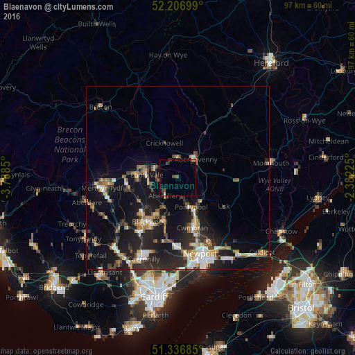
Analysis of Blaenavon night lights 2016
Square area 10x10 km:
 0.14%
0.14%90-99
0.42%80-89
0%70-79
0.14%60-69
0.42%50-59
1.26%40-49
1.82%30-39
0.7%20-29
1.82%10-19
0.42%0-9
92.86%Square area 50x50 km:
1.35%90-99
1.94%80-89
0.93%70-79
1.39%60-69
1.37%50-59
1.58%40-49
1.68%30-39
2.01%20-29
4.63%10-19
11.19%0-9
71.94%Clear (daylight) street map image can be seen on geolist.org.
Map coordinates:
52° 12' 25.2" North, 3° 47' 18.6" West
51° 46' 26.5" North, 3° 5' 7.3" West
51° 20' 12.7" North, 2° 22' 56.1" West
Some cities around Blaenavon sort by population:
• Pontypool
8.6 km =5.3 mi,  160°
160°
• Ebbw Vale
8.4 km =5.2 mi,  272°
272°
• Brynmawr
7.3 km =4.5 mi,  293°
293°
• Tredegar
11.1 km =6.9 mi, 269°
• Abergavenny
7 km =4.3 mi,  41°
41°
• Abertillery
6 km =3.7 mi,  214°
214°
• Victoria
8.3 km =5.2 mi,  251°
251°
• Crumlin
11.2 km =7 mi,  197°
197°
2655413 (p: 5,647)
Sources (retrieved 2019-11-25):
» Earth at Night: Flat Maps 2012, 2016