Wingles night lights from space
Night Light of Wingles (Hauts-de-France) from space (France) Src. Average luminocity for 10x10km area is 78.93% and for 50x50km: 47.1239%.
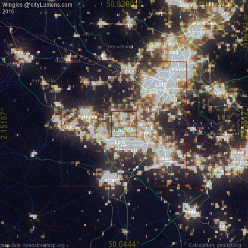
Analysis of Wingles night lights 2016
Square area 10x10 km:
 16.95%
90-99
24.51%80-89
11.76%70-79
12.75%60-69
14.71%50-59
7.7%40-49
10.08%30-39
1.54%20-29
0%10-19
0%0-9
0%Square area 50x50 km:
12.48%90-99
10.76%80-89
4.03%70-79
4.89%60-69
5.66%50-59
5.34%40-49
6.04%30-39
7.38%20-29
10.72%10-19
16.3%0-9
16.4%Clear (daylight) street map image can be seen on geolist.org.
Map coordinates:
50° 56' 20.4" North, 2° 9' 6.7" East
50° 29' 37.8" North, 2° 51' 18" East
50° 2' 39.8" North, 3° 33' 29.2" East
Some cities around Wingles sort by population:
• Harnes
6.3 km =3.9 mi,  146°
146°
• Annoeullin
6.7 km =4.2 mi,  54°
54°
• Loos-en-Gohelle
6 km =3.7 mi,  228°
228°
• Vendin-le-Vieil
2.4 km =1.5 mi,  159°
159°
• La Bassée
5.7 km =3.5 mi,  322°
322°
• Loison-sous-Lens
6.2 km =3.9 mi,  181°
181°
• Bauvin
3.8 km =2.4 mi, 46°
• Douvrin
2.4 km =1.5 mi,  314°
314°
2967343 (p: 8,815)
Sources (retrieved 2019-11-25):
» Earth at Night: Flat Maps 2012, 2016