Loos-en-Gohelle night lights from space
Night Light of Loos-en-Gohelle (Hauts-de-France) from space (France) Src. Average luminocity for 10x10km area is 82.2423% and for 50x50km: 42.8714%.
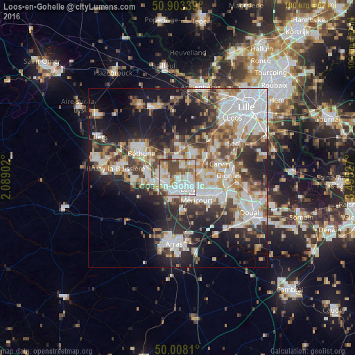
Analysis of Loos-en-Gohelle night lights 2016
Square area 10x10 km:
 27.31%
90-99
29.41%80-89
6.58%70-79
8.96%60-69
6.72%50-59
5.46%40-49
12.32%30-39
3.22%20-29
0%10-19
0%0-9
0%Square area 50x50 km:
10.82%90-99
10.09%80-89
3.86%70-79
4.39%60-69
5.11%50-59
4.77%40-49
5.4%30-39
6.5%20-29
10.18%10-19
15.62%0-9
23.27%Clear (daylight) street map image can be seen on geolist.org.
Map coordinates:
50° 54' 12.2" North, 2° 5' 20.5" East
50° 27' 28.3" North, 2° 47' 31.7" East
50° 0' 29.2" North, 3° 29' 43" East
Some cities around Loos-en-Gohelle sort by population:
• Lens
3.7 km =2.3 mi,  137°
137°
• Liévin
4.3 km =2.7 mi,  190°
190°
• Avion
5.9 km =3.7 mi,  152°
152°
• Bully-les-Mines
4.9 km =3 mi,  251°
251°
• Mazingarbe
5.6 km =3.5 mi,  285°
285°
• Vendin-le-Vieil
5.6 km =3.5 mi,  71°
71°
• Grenay
3 km =1.9 mi, 252°
• Loison-sous-Lens
4.9 km =3 mi,  117°
117°
2997619 (p: 7,150)
Sources (retrieved 2019-11-25):
» Earth at Night: Flat Maps 2012, 2016