Loison-sous-Lens night lights from space
Night Light of Loison-sous-Lens (Hauts-de-France) from space (France) Src. Average luminocity for 10x10km area is 89.3711% and for 50x50km: 42.9828%.
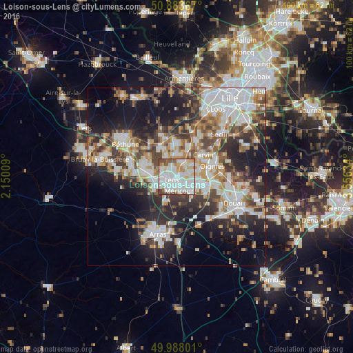
Analysis of Loison-sous-Lens night lights 2016
Square area 10x10 km:
 34.17%
90-99
35.57%80-89
10.36%70-79
5.32%60-69
4.34%50-59
4.2%40-49
4.76%30-39
1.26%20-29
0%10-19
0%0-9
0%Square area 50x50 km:
10.34%90-99
10.06%80-89
3.75%70-79
4.43%60-69
5.42%50-59
4.89%40-49
5.73%30-39
6.78%20-29
10.73%10-19
15.78%0-9
22.1%Clear (daylight) street map image can be seen on geolist.org.
Map coordinates:
50° 53' 1.2" North, 2° 9' 0.3" East
50° 26' 16.7" North, 2° 51' 11.6" East
49° 59' 16.8" North, 3° 33' 22.8" East
Some cities around Loison-sous-Lens sort by population:
• Lens
1.9 km =1.2 mi,  252°
252°
• Avion
3.5 km =2.2 mi,  207°
207°
• Harnes
3.8 km =2.4 mi,  75°
75°
• Méricourt
4.1 km =2.5 mi,  170°
170°
• Sallaumines
2.4 km =1.5 mi, 165°
• Billy-Montigny
4.2 km =2.6 mi,  123°
123°
• Noyelles-sous-Lens
1.6 km =1 mi, 120°
• Vendin-le-Vieil
4.1 km =2.5 mi,  13°
13°
2997841 (p: 5,683)
Sources (retrieved 2019-11-25):
» Earth at Night: Flat Maps 2012, 2016