Vitry-le-François night lights from space
Night Light of Vitry-le-François (Grand Est) from space (France) Src. Average luminocity for 10x10km area is 21.7827% and for 50x50km: 2.4299%.
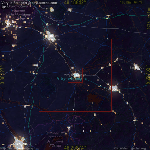
Analysis of Vitry-le-François night lights 2016
Square area 10x10 km:
 5.51%
5.51%90-99
4.61%80-89
1.79%70-79
1.04%60-69
1.49%50-59
2.23%40-49
0.89%30-39
0.74%20-29
2.38%10-19
27.83%0-9
51.49%Square area 50x50 km:
0.44%90-99
0.5%80-89
0.17%70-79
0.11%60-69
0.18%50-59
0.26%40-49
0.19%30-39
0.27%20-29
0.37%10-19
2.6%0-9
94.91%Clear (daylight) street map image can be seen on geolist.org.
Map coordinates:
49° 11' 11.1" North, 3° 52' 52.6" East
48° 43' 29" North, 4° 35' 3.8" East
48° 15' 31.5" North, 5° 17' 15.1" East
Some cities around Vitry-le-François sort by population:
• Châlons-en-Champagne
30 km =18.6 mi,  328°
328°
• Saint-Dizier
28.5 km =17.7 mi,  109°
109°
• Bar-le-Duc
42.6 km =26.5 mi,  82°
82°
• Saint-Memmie
29.3 km =18.2 mi, 329°
• Mourmelon-le-Grand
48.1 km =29.9 mi,  340°
340°
• Bar-sur-Aube
55.4 km =34.4 mi,  170°
170°
• Ligny-en-Barrois
54.5 km =33.9 mi,  94°
94°
• Sainte-Menehould
46.6 km =29 mi,  29°
29°
2967856 (p: 17,250)
Sources (retrieved 2019-11-25):
» Earth at Night: Flat Maps 2012, 2016