Viry-Châtillon night lights from space
Night Light of Viry-Châtillon (Île-de-France) from space (France) Src. Average luminocity for 10x10km area is 94.0774% and for 50x50km: 58.3309%.
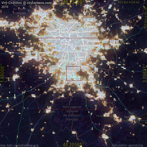

Analysis of Viry-Châtillon night lights 2016
Square area 10x10 km:
 49.85%
90-99
34.97%80-89
2.83%70-79
5.06%60-69
1.04%50-59
4.17%40-49
2.08%30-39
0%20-29
0%10-19
0%0-9
0%Square area 50x50 km:
24.57%90-99
14.47%80-89
4.09%70-79
4.42%60-69
5.32%50-59
4.06%40-49
4.97%30-39
4.92%20-29
6.22%10-19
9.28%0-9
17.68%Clear (daylight) street map image can be seen on geolist.org.
Map coordinates:
49° 8' 3.4" North, 1° 41' 24.2" East
48° 40' 19.6" North, 2° 23' 35.4" East
48° 12' 20.3" North, 3° 5' 46.7" East
Some cities around Viry-Châtillon sort by population:
• Savigny-sur-Orge
3.3 km =2.1 mi,  278°
278°
• Athis-Mons
3.7 km =2.3 mi,  358°
358°
• Draveil
2.1 km =1.3 mi,  47°
47°
• Vigneux-sur-Seine
3.7 km =2.3 mi,  23°
23°
• Ris-Orangis
2.8 km =1.7 mi,  146°
146°
• Grigny
2 km =1.2 mi,  179°
179°
• Morsang-sur-Orge
3.1 km =1.9 mi,  248°
248°
• Juvisy-sur-Orge
1.4 km =0.9 mi,  329°
329°
2967917 (p: 31,131)
Sources (retrieved 2019-11-25):
» Earth at Night: Flat Maps 2012, 2016