Ris-Orangis night lights from space
Night Light of Ris-Orangis (Île-de-France) from space (France) Src. Average luminocity for 10x10km area is 89.0699% and for 50x50km: 54.0485%.
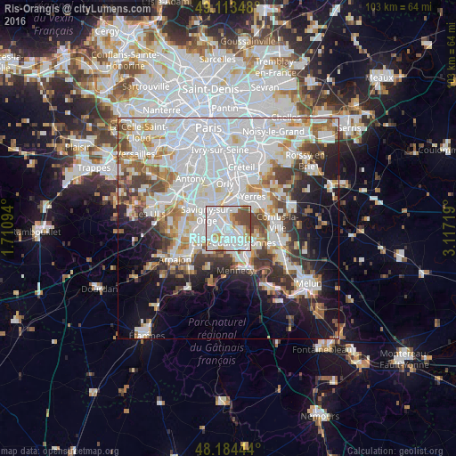

Analysis of Ris-Orangis night lights 2016
Square area 10x10 km:
 38.69%
90-99
33.78%80-89
4.32%70-79
7.29%60-69
2.98%50-59
5.06%40-49
7.89%30-39
0%20-29
0%10-19
0%0-9
0%Square area 50x50 km:
21.5%90-99
13.48%80-89
3.82%70-79
4.42%60-69
5.2%50-59
4%40-49
4.74%30-39
4.78%20-29
6.31%10-19
10.4%0-9
21.36%Clear (daylight) street map image can be seen on geolist.org.
Map coordinates:
49° 6' 48.5" North, 1° 42' 39.4" East
48° 39' 4" North, 2° 24' 50.6" East
48° 11' 4" North, 3° 7' 1.9" East
Some cities around Ris-Orangis sort by population:
• Évry
2.8 km =1.7 mi,  136°
136°
• Viry-Châtillon
2.8 km =1.7 mi,  326°
326°
• Draveil
3.7 km =2.3 mi,  0°
0°
• Grigny
1.6 km =1 mi,  282°
282°
• Courcouronnes
4.1 km =2.5 mi,  186°
186°
• Juvisy-sur-Orge
4.2 km =2.6 mi, 327°
• Fleury-Mérogis
4 km =2.5 mi,  247°
247°
• Soisy-sur-Seine
2.8 km =1.7 mi,  95°
95°
2983440 (p: 25,082)
Sources (retrieved 2019-11-25):
» Earth at Night: Flat Maps 2012, 2016