Juvisy-sur-Orge night lights from space
Night Light of Juvisy-sur-Orge (Île-de-France) from space (France) Src. Average luminocity for 10x10km area is 95.7247% and for 50x50km: 60.4875%.
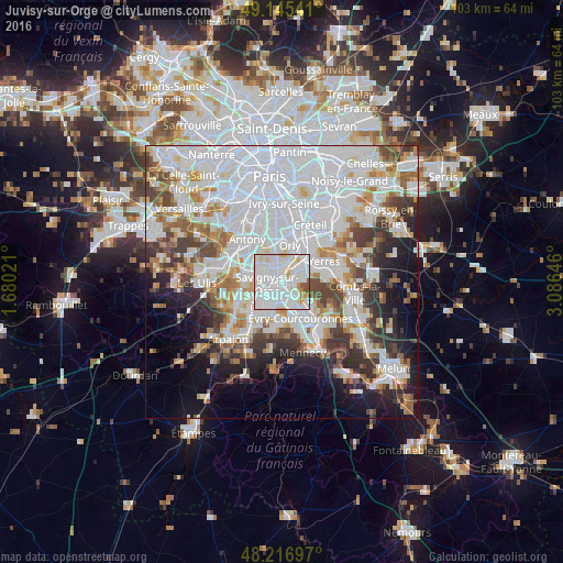
Analysis of Juvisy-sur-Orge night lights 2016
Square area 10x10 km:
 50.15%
90-99
37.35%80-89
5.8%70-79
2.98%60-69
0.89%50-59
2.68%40-49
0.15%30-39
0%20-29
0%10-19
0%0-9
0%Square area 50x50 km:
26.48%90-99
14.79%80-89
4.12%70-79
4.42%60-69
5.31%50-59
4.07%40-49
5.05%30-39
5.15%20-29
6.02%10-19
8.4%0-9
16.18%Clear (daylight) street map image can be seen on geolist.org.
Map coordinates:
49° 8' 43.5" North, 1° 40' 48.8" East
48° 40' 60" North, 2° 22' 60" East
48° 13' 1.1" North, 3° 5' 11.3" East
Some cities around Juvisy-sur-Orge sort by population:
• Savigny-sur-Orge
2.7 km =1.7 mi,  254°
254°
• Athis-Mons
2.5 km =1.6 mi,  13°
13°
• Viry-Châtillon
1.4 km =0.9 mi,  149°
149°
• Draveil
2.3 km =1.4 mi,  86°
86°
• Vigneux-sur-Seine
3.1 km =1.9 mi,  45°
45°
• Grigny
3.3 km =2.1 mi,  167°
167°
• Morsang-sur-Orge
3.2 km =2 mi,  222°
222°
• Paray-Vieille-Poste
3.7 km =2.3 mi,  336°
336°
3011988 (p: 12,376)
Sources (retrieved 2019-11-25):
» Earth at Night: Flat Maps 2012, 2016