Villecresnes night lights from space
Night Light of Villecresnes (Île-de-France) from space (France) Src. Average luminocity for 10x10km area is 77.4747% and for 50x50km: 60.1421%.
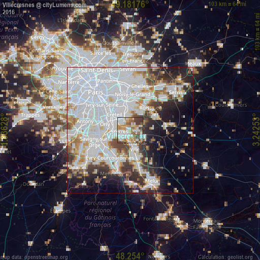
Analysis of Villecresnes night lights 2016
Square area 10x10 km:
 20.09%
90-99
23.96%80-89
6.55%70-79
14.43%60-69
10.57%50-59
7.89%40-49
11.61%30-39
4.91%20-29
0%10-19
0%0-9
0%Square area 50x50 km:
28.84%90-99
13.71%80-89
3.58%70-79
4.01%60-69
4.5%50-59
3.42%40-49
4.27%30-39
4.99%20-29
6.89%10-19
8.4%0-9
17.39%Clear (daylight) street map image can be seen on geolist.org.
Map coordinates:
49° 10' 54.3" North, 1° 50' 10.6" East
48° 43' 12.1" North, 2° 32' 21.8" East
48° 15' 14.4" North, 3° 14' 33.1" East
Some cities around Villecresnes sort by population:
• Yerres
3.4 km =2.1 mi,  265°
265°
• Sucy-en-Brie
5.4 km =3.4 mi,  356°
356°
• Brunoy
4.5 km =2.8 mi,  230°
230°
• Limeil-Brévannes
4.7 km =2.9 mi,  305°
305°
• Boissy-Saint-Léger
4 km =2.5 mi,  329°
329°
• Épinay-sous-Sénart
3.9 km =2.4 mi,  210°
210°
• Quincy-sous-Sénart
5.2 km =3.2 mi,  184°
184°
• Boussy-Saint-Antoine
3.3 km =2.1 mi,  191°
191°
2968823 (p: 8,978)
Sources (retrieved 2019-11-25):
» Earth at Night: Flat Maps 2012, 2016