Boissy-Saint-Léger night lights from space
Night Light of Boissy-Saint-Léger (Île-de-France) from space (France) Src. Average luminocity for 10x10km area is 87.7634% and for 50x50km: 65.7564%.
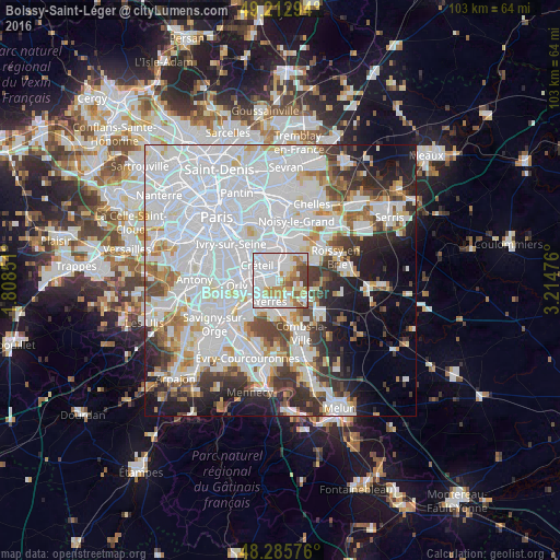
Analysis of Boissy-Saint-Léger night lights 2016
Square area 10x10 km:
 46.28%
90-99
18.75%80-89
4.91%70-79
13.1%60-69
6.85%50-59
5.51%40-49
4.17%30-39
0.45%20-29
0%10-19
0%0-9
0%Square area 50x50 km:
31.98%90-99
15.72%80-89
4.01%70-79
4.31%60-69
4.63%50-59
3.51%40-49
4.33%30-39
5.08%20-29
6.67%10-19
8.21%0-9
11.56%Clear (daylight) street map image can be seen on geolist.org.
Map coordinates:
49° 12' 46.6" North, 1° 48' 30.6" East
48° 45' 5.4" North, 2° 30' 41.9" East
48° 17' 8.7" North, 3° 12' 53.1" East
Some cities around Boissy-Saint-Léger sort by population:
• Saint-Maur-des-Fossés
4.9 km =3 mi,  344°
344°
• Yerres
4 km =2.5 mi,  199°
199°
• Sucy-en-Brie
2.6 km =1.6 mi,  41°
41°
• Limeil-Brévannes
1.9 km =1.2 mi,  247°
247°
• Bonneuil-sur-Marne
3.1 km =1.9 mi,  310°
310°
• Valenton
3.5 km =2.2 mi,  258°
258°
• Ormesson-sur-Marne
4.6 km =2.9 mi,  32°
32°
• Villecresnes
4 km =2.5 mi,  149°
149°
3031898 (p: 15,877)
Sources (retrieved 2019-11-25):
» Earth at Night: Flat Maps 2012, 2016