Valfin-lès-Saint-Claude night lights from space
Night Light of Valfin-lès-Saint-Claude (Bourgogne-Franche-Comté) from space (France) Src. Average luminocity for 10x10km area is 2.2976% and for 50x50km: 7.1571%.
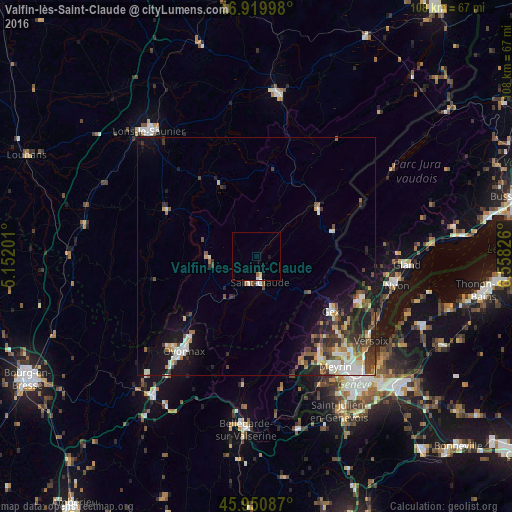
Analysis of Valfin-lès-Saint-Claude night lights 2016
Square area 10x10 km:
 0.3%
0.3%90-99
0.3%80-89
0.6%70-79
0%60-69
0.6%50-59
0%40-49
0%30-39
0%20-29
0%10-19
0.6%0-9
97.62%Square area 50x50 km:
1.07%90-99
1.49%80-89
0.61%70-79
0.6%60-69
0.86%50-59
0.89%40-49
1.34%30-39
1.32%20-29
1.72%10-19
4.7%0-9
85.39%Clear (daylight) street map image can be seen on geolist.org.
Map coordinates:
46° 55' 11.9" North, 5° 9' 7.2" East
46° 26' 15.3" North, 5° 51' 18.5" East
45° 57' 3.1" North, 6° 33' 29.7" East
Some cities around Valfin-lès-Saint-Claude sort by population:
• Oyonnax
25 km =15.5 mi,  217°
217°
• Meyrin, CH
28.5 km =17.7 mi,  142°
142°
• Saint-Claude
5.7 km =3.5 mi,  172°
172°
• Gex
19.4 km =12.1 mi,  126°
126°
• Ferney-Voltaire
27.9 km =17.3 mi, 135°
• Saint-Genis-Pouilly
25.1 km =15.6 mi,  149°
149°
• Divonne-les-Bains
23.2 km =14.4 mi,  112°
112°
• Morez
16.3 km =10.1 mi,  53°
53°
2971006 (p: 12,966)
Sources (retrieved 2019-11-25):
» Earth at Night: Flat Maps 2012, 2016