Ferney-Voltaire night lights from space
Night Light of Ferney-Voltaire (Auvergne-Rhône-Alpes) from space (France) Src. Average luminocity for 10x10km area is 61.4122% and for 50x50km: 17.6874%.
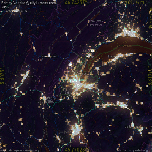
Analysis of Ferney-Voltaire night lights 2016
Square area 10x10 km:
 13.69%
90-99
15.92%80-89
6.55%70-79
4.46%60-69
8.18%50-59
6.1%40-49
11.46%30-39
17.26%20-29
15.18%10-19
1.19%0-9
0%Square area 50x50 km:
2.25%90-99
2.92%80-89
1.43%70-79
1.73%60-69
2.24%50-59
2.46%40-49
3.47%30-39
3.46%20-29
4.55%10-19
15.59%0-9
59.9%Clear (daylight) street map image can be seen on geolist.org.
Map coordinates:
46° 44' 33.3" North, 5° 24' 27" East
46° 15' 30.9" North, 6° 6' 38.3" East
45° 46' 13" North, 6° 48' 49.5" East
Some cities around Ferney-Voltaire sort by population:
• Genève, CH
6.8 km =4.2 mi,  156°
156°
• Vernier, CH
5 km =3.1 mi,  203°
203°
• Lancy, CH
7.7 km =4.8 mi,  177°
177°
• Meyrin, CH
3.6 km =2.2 mi,  220°
220°
• Versoix, CH
4.9 km =3 mi,  54°
54°
• Le Grand-Saconnex, CH
3.1 km =1.9 mi,  165°
165°
• Saint-Genis-Pouilly
7.1 km =4.4 mi,  256°
256°
• Les Avanchets, CH
4.1 km =2.5 mi, 182°
3018679 (p: 7,742)
Sources (retrieved 2019-11-25):
» Earth at Night: Flat Maps 2012, 2016