Saint-Genis-Pouilly night lights from space
Night Light of Saint-Genis-Pouilly (Auvergne-Rhône-Alpes) from space (France) Src. Average luminocity for 10x10km area is 41.4658% and for 50x50km: 15.7481%.
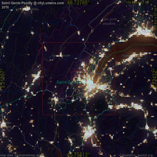
Analysis of Saint-Genis-Pouilly night lights 2016
Square area 10x10 km:
 5.51%
5.51%90-99
7.59%80-89
4.46%70-79
5.8%60-69
4.61%50-59
8.18%40-49
8.78%30-39
11.9%20-29
8.04%10-19
16.96%0-9
18.15%Square area 50x50 km:
2.05%90-99
2.62%80-89
1.32%70-79
1.55%60-69
1.93%50-59
2.38%40-49
3.1%30-39
3.12%20-29
4.23%10-19
12.68%0-9
65.01%Clear (daylight) street map image can be seen on geolist.org.
Map coordinates:
46° 43' 39.6" North, 5° 19' 5.1" East
46° 14' 36.8" North, 6° 1' 16.3" East
45° 45' 18.5" North, 6° 43' 27.6" East
Some cities around Saint-Genis-Pouilly sort by population:
• Vernier, CH
5.7 km =3.5 mi,  121°
121°
• Lancy, CH
9.3 km =5.8 mi,  129°
129°
• Meyrin, CH
4.7 km =2.9 mi,  102°
102°
• Onex, CH
9.1 km =5.7 mi,  136°
136°
• Le Grand-Saconnex, CH
7.8 km =4.8 mi, 99°
• Bernex, CH
8.5 km =5.3 mi,  150°
150°
• Ferney-Voltaire
7.1 km =4.4 mi,  76°
76°
• Les Avanchets, CH
7.1 km =4.4 mi,  109°
109°
2979983 (p: 7,428)
Sources (retrieved 2019-11-25):
» Earth at Night: Flat Maps 2012, 2016