Gex night lights from space
Night Light of Gex (Auvergne-Rhône-Alpes) from space (France) Src. Average luminocity for 10x10km area is 23.4152% and for 50x50km: 15.1603%.
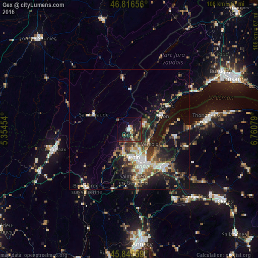
Analysis of Gex night lights 2016
Square area 10x10 km:
 1.19%
1.19%90-99
3.87%80-89
1.79%70-79
3.57%60-69
1.79%50-59
2.68%40-49
3.57%30-39
3.72%20-29
14.43%10-19
27.23%0-9
36.16%Square area 50x50 km:
1.99%90-99
2.56%80-89
1.22%70-79
1.44%60-69
1.97%50-59
2.23%40-49
3.17%30-39
3.09%20-29
4.06%10-19
12.07%0-9
66.22%Clear (daylight) street map image can be seen on geolist.org.
Map coordinates:
46° 48' 59.6" North, 5° 21' 16.3" East
46° 19' 59.6" North, 6° 3' 27.6" East
45° 50' 44.1" North, 6° 45' 38.8" East
Some cities around Gex sort by population:
• Vernier, CH
13.1 km =8.1 mi,  170°
170°
• Meyrin, CH
11.1 km =6.9 mi, 171°
• Versoix, CH
9.7 km =6 mi,  124°
124°
• Le Grand-Saconnex, CH
12.3 km =7.6 mi,  156°
156°
• Ferney-Voltaire
9.2 km =5.7 mi,  153°
153°
• Saint-Genis-Pouilly
10.4 km =6.5 mi,  195°
195°
• Divonne-les-Bains
6.5 km =4 mi,  65°
65°
• Les Avanchets, CH
13 km =8.1 mi, 162°
3016143 (p: 9,177)
Sources (retrieved 2019-11-25):
» Earth at Night: Flat Maps 2012, 2016