Saint-Claude night lights from space
Night Light of Saint-Claude (Bourgogne-Franche-Comté) from space (France) Src. Average luminocity for 10x10km area is 6.683% and for 50x50km: 9.8799%.
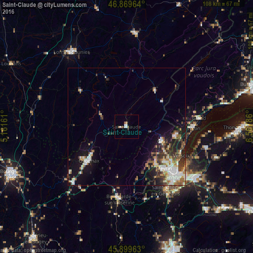
Analysis of Saint-Claude night lights 2016
Square area 10x10 km:
 1.64%
1.64%90-99
1.34%80-89
0.6%70-79
0%60-69
1.04%50-59
1.34%40-49
1.04%30-39
0.15%20-29
0%10-19
0%0-9
92.86%Square area 50x50 km:
1.64%90-99
2.12%80-89
0.83%70-79
0.86%60-69
1.27%50-59
1.18%40-49
1.79%30-39
1.7%20-29
2.25%10-19
6.34%0-9
80.03%Clear (daylight) street map image can be seen on geolist.org.
Map coordinates:
46° 52' 10.7" North, 5° 9' 41.8" East
46° 23' 12.4" North, 5° 51' 53" East
45° 53' 58.7" North, 6° 34' 4.3" East
Some cities around Saint-Claude sort by population:
• Vernier, CH
25.3 km =15.7 mi,  138°
138°
• Oyonnax
21.3 km =13.2 mi,  228°
228°
• Meyrin, CH
23.7 km =14.7 mi, 135°
• Valfin-lès-Saint-Claude
5.7 km =3.5 mi,  352°
352°
• Gex
16 km =9.9 mi,  111°
111°
• Ferney-Voltaire
23.7 km =14.7 mi,  127°
127°
• Divonne-les-Bains
21 km =13 mi,  99°
99°
• Morez
19.7 km =12.2 mi,  38°
38°
2981077 (p: 12,418)
Sources (retrieved 2019-11-25):
» Earth at Night: Flat Maps 2012, 2016