L’Isle-d’Abeau night lights from space
Night Light of L’Isle-d’Abeau (Auvergne-Rhône-Alpes) from space (France) Src. Average luminocity for 10x10km area is 42.95% and for 50x50km: 20.4979%.
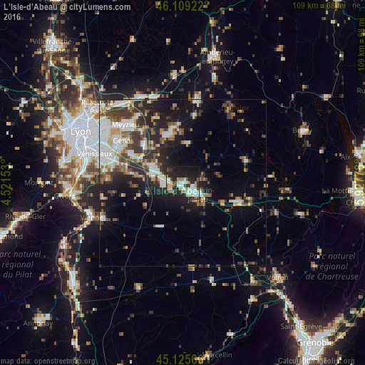
Analysis of L’Isle-d’Abeau night lights 2016
Square area 10x10 km:
 8.33%
8.33%90-99
10.91%80-89
4.24%70-79
2.27%60-69
4.09%50-59
6.36%40-49
2.58%30-39
5.15%20-29
21.82%10-19
30.45%0-9
3.79%Square area 50x50 km:
3.75%90-99
4.06%80-89
1.56%70-79
2.02%60-69
2.2%50-59
2.77%40-49
2.9%30-39
4.3%20-29
6.51%10-19
10.85%0-9
59.07%Clear (daylight) street map image can be seen on geolist.org.
Map coordinates:
46° 6' 33.2" North, 4° 31' 17.5" East
45° 37' 10.6" North, 5° 13' 28.8" East
45° 7' 32.4" North, 5° 55' 40" East
Some cities around L’Isle-d’Abeau sort by population:
• Bourgoin-Jallieu
5.3 km =3.3 mi,  134°
134°
• Villefontaine
5.8 km =3.6 mi,  262°
262°
• Charvieu-Chavagneux
15.6 km =9.7 mi,  338°
338°
• La Tour-du-Pin
18.1 km =11.2 mi,  109°
109°
• Saint-Quentin-Fallavier
9.1 km =5.7 mi,  286°
286°
• La Verpillière
6.4 km =4 mi,  284°
284°
• Saint-Bonnet-de-Mure
17.1 km =10.6 mi,  297°
297°
• Tignieu
14.9 km =9.3 mi,  349°
349°
2998136 (p: 12,033)
Sources (retrieved 2019-11-25):
» Earth at Night: Flat Maps 2012, 2016