Crépy-en-Valois night lights from space
Night Light of Crépy-en-Valois (Hauts-de-France) from space (France) Src. Average luminocity for 10x10km area is 10.4412% and for 50x50km: 9.5981%.
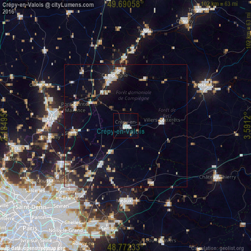
Analysis of Crépy-en-Valois night lights 2016
Square area 10x10 km:
 2.41%
2.41%90-99
2.94%80-89
0.53%70-79
0%60-69
0.94%50-59
0.4%40-49
1.07%30-39
0.4%20-29
0.67%10-19
2.01%0-9
88.64%Square area 50x50 km:
1.46%90-99
1.67%80-89
0.78%70-79
0.8%60-69
0.94%50-59
1.17%40-49
1%30-39
1.03%20-29
2.92%10-19
8.18%0-9
80.05%Clear (daylight) street map image can be seen on geolist.org.
Map coordinates:
49° 41' 26.1" North, 2° 11' 5.8" East
49° 14' 0.9" North, 2° 53' 17.1" East
48° 46' 20.4" North, 3° 35' 28.3" East
Some cities around Crépy-en-Valois sort by population:
• Compiègne
21 km =13 mi,  347°
347°
• Senlis
22.1 km =13.7 mi,  262°
262°
• Pont-Sainte-Maxence
21.9 km =13.6 mi,  290°
290°
• Villers-Cotterêts
14.8 km =9.2 mi,  81°
81°
• Dammartin-en-Goële
25.1 km =15.6 mi,  217°
217°
• Othis
23.6 km =14.7 mi, 221°
• Margny-lès-Compiègne
21.9 km =13.6 mi, 346°
• Saint-Pathus
19.2 km =11.9 mi,  199°
199°
3022569 (p: 15,694)
Sources (retrieved 2019-11-25):
» Earth at Night: Flat Maps 2012, 2016