Thiers night lights from space
Night Light of Thiers (Auvergne-Rhône-Alpes) from space (France) Src. Average luminocity for 10x10km area is 17.1786% and for 50x50km: 2.2214%.
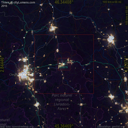
Analysis of Thiers night lights 2016
Square area 10x10 km:
 0.45%
0.45%90-99
1.49%80-89
1.34%70-79
3.87%60-69
1.34%50-59
4.76%40-49
4.02%30-39
3.57%20-29
3.27%10-19
2.53%0-9
73.36%Square area 50x50 km:
0.05%90-99
0.2%80-89
0.15%70-79
0.31%60-69
0.28%50-59
0.57%40-49
0.47%30-39
0.54%20-29
0.47%10-19
0.78%0-9
96.17%Clear (daylight) street map image can be seen on geolist.org.
Map coordinates:
46° 20' 38.7" North, 2° 50' 40.1" East
45° 51' 23.5" North, 3° 32' 51.3" East
45° 21' 52.9" North, 4° 15' 2.6" East
Some cities around Thiers sort by population:
• Vichy
31.5 km =19.6 mi,  342°
342°
• Cournon-d’Auvergne
30.1 km =18.7 mi,  244°
244°
• Cusset
31.7 km =19.7 mi,  347°
347°
• Pont-du-Château
24.1 km =15 mi,  254°
254°
• Gerzat
31.4 km =19.5 mi,  263°
263°
• Bellerive-sur-Allier
31 km =19.3 mi, 339°
• Lezoux
13.4 km =8.3 mi, 255°
• Le Cendre
31.7 km =19.7 mi, 241°
2972857 (p: 13,739)
Sources (retrieved 2019-11-25):
» Earth at Night: Flat Maps 2012, 2016