Pont-du-Château night lights from space
Night Light of Pont-du-Château (Auvergne-Rhône-Alpes) from space (France) Src. Average luminocity for 10x10km area is 17.8438% and for 50x50km: 8.4881%.
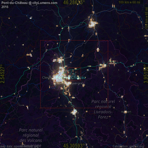
Analysis of Pont-du-Château night lights 2016
Square area 10x10 km:
 1.79%
1.79%90-99
3.87%80-89
0.74%70-79
1.34%60-69
1.79%50-59
1.49%40-49
2.68%30-39
3.27%20-29
6.99%10-19
19.79%0-9
56.25%Square area 50x50 km:
1.38%90-99
1.64%80-89
0.66%70-79
0.77%60-69
0.92%50-59
1.3%40-49
1.04%30-39
1.41%20-29
2.8%10-19
4.77%0-9
83.3%Clear (daylight) street map image can be seen on geolist.org.
Map coordinates:
46° 17' 10.9" North, 2° 32' 43" East
45° 47' 53.9" North, 3° 14' 54.2" East
45° 18' 21.3" North, 3° 57' 5.5" East
Some cities around Pont-du-Château sort by population:
• Clermont-Ferrand
12.7 km =7.9 mi,  260°
260°
• Cournon-d’Auvergne
7.5 km =4.7 mi,  212°
212°
• Aubière
11.9 km =7.4 mi,  243°
243°
• Gerzat
8.6 km =5.3 mi,  290°
290°
• Romagnat
13.8 km =8.6 mi, 236°
• Cébazat
12.1 km =7.5 mi, 287°
• Lezoux
10.6 km =6.6 mi,  72°
72°
• Le Cendre
9.7 km =6 mi, 209°
2986219 (p: 9,474)
Sources (retrieved 2019-11-25):
» Earth at Night: Flat Maps 2012, 2016