Sury-le-Comtal night lights from space
Night Light of Sury-le-Comtal (Auvergne-Rhône-Alpes) from space (France) Src. Average luminocity for 10x10km area is 24.6576% and for 50x50km: 12.1539%.
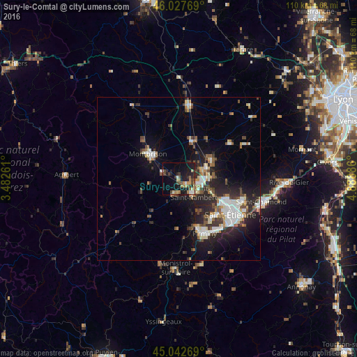
Analysis of Sury-le-Comtal night lights 2016
Square area 10x10 km:
 0.91%
0.91%90-99
2.42%80-89
3.94%70-79
2.88%60-69
5%50-59
1.82%40-49
6.67%30-39
3.64%20-29
8.03%10-19
23.94%0-9
40.76%Square area 50x50 km:
1.86%90-99
2.37%80-89
1%70-79
1.02%60-69
1.33%50-59
1.49%40-49
1.96%30-39
1.69%20-29
4.65%10-19
7.73%0-9
74.89%Clear (daylight) street map image can be seen on geolist.org.
Map coordinates:
46° 1' 39.7" North, 3° 28' 57.4" East
45° 32' 14.5" North, 4° 11' 8.6" East
45° 2' 33.7" North, 4° 53' 19.9" East
Some cities around Sury-le-Comtal sort by population:
• Montbrison
12.2 km =7.6 mi,  309°
309°
• Saint-Just-Saint-Rambert
6 km =3.7 mi,  133°
133°
• Roche-la-Molière
16.2 km =10.1 mi,  136°
136°
• Andrézieux-Bouthéon
5.9 km =3.7 mi,  102°
102°
• Villars
15.3 km =9.5 mi,  120°
120°
• Veauche
8.8 km =5.5 mi,  70°
70°
• Saint-Genest-Lerpt
15.9 km =9.9 mi, 131°
• Saint-Galmier
11.8 km =7.3 mi,  55°
55°
2973639 (p: 5,046)
Sources (retrieved 2019-11-25):
» Earth at Night: Flat Maps 2012, 2016