Saint-Galmier night lights from space
Night Light of Saint-Galmier (Auvergne-Rhône-Alpes) from space (France) Src. Average luminocity for 10x10km area is 22.4561% and for 50x50km: 14.1037%.
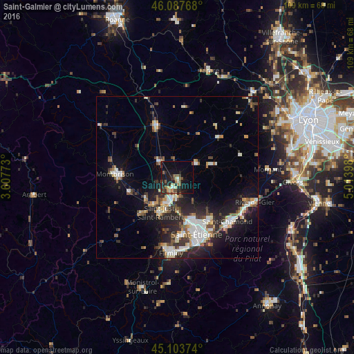
Analysis of Saint-Galmier night lights 2016
Square area 10x10 km:
 1.06%
1.06%90-99
1.67%80-89
3.79%70-79
1.52%60-69
3.18%50-59
6.36%40-49
3.33%30-39
1.82%20-29
10.61%10-19
22.73%0-9
43.94%Square area 50x50 km:
2.17%90-99
2.83%80-89
1.24%70-79
1.21%60-69
1.53%50-59
1.74%40-49
2.08%30-39
2.01%20-29
4.87%10-19
9.02%0-9
71.3%Clear (daylight) street map image can be seen on geolist.org.
Map coordinates:
46° 5' 15.6" North, 3° 36' 27.8" East
45° 35' 52.3" North, 4° 18' 39.1" East
45° 6' 13.5" North, 5° 0' 50.3" East
Some cities around Saint-Galmier sort by population:
• Roche-la-Molière
18.6 km =11.6 mi,  175°
175°
• Andrézieux-Bouthéon
8.9 km =5.5 mi,  206°
206°
• Villars
14.9 km =9.3 mi,  166°
166°
• Veauche
4.1 km =2.5 mi,  200°
200°
• Feurs
16.4 km =10.2 mi,  336°
336°
• Sorbiers
15.6 km =9.7 mi,  139°
139°
• La Talaudière
16.2 km =10.1 mi,  146°
146°
• Sury-le-Comtal
11.8 km =7.3 mi,  235°
235°
2980052 (p: 5,485)
Sources (retrieved 2019-11-25):
» Earth at Night: Flat Maps 2012, 2016