Saint-Just-Saint-Rambert night lights from space
Night Light of Saint-Just-Saint-Rambert (Auvergne-Rhône-Alpes) from space (France) Src. Average luminocity for 10x10km area is 38.5032% and for 50x50km: 12.7927%.
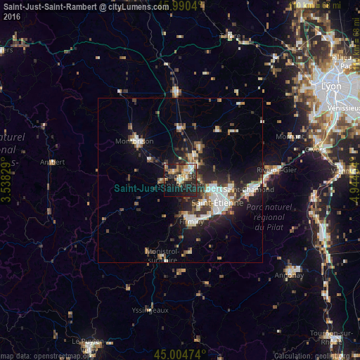
Analysis of Saint-Just-Saint-Rambert night lights 2016
Square area 10x10 km:
 3.65%
3.65%90-99
7.46%80-89
5.4%70-79
6.03%60-69
6.83%50-59
2.06%40-49
4.92%30-39
4.6%20-29
17.62%10-19
30.79%0-9
10.63%Square area 50x50 km:
1.98%90-99
2.47%80-89
1.06%70-79
0.99%60-69
1.5%50-59
1.52%40-49
2.02%30-39
1.73%20-29
4.68%10-19
8.78%0-9
73.27%Clear (daylight) street map image can be seen on geolist.org.
Map coordinates:
45° 59' 25.4" North, 3° 32' 17.8" East
45° 29' 59" North, 4° 14' 29.1" East
45° 0' 17.1" North, 4° 56' 40.3" East
Some cities around Saint-Just-Saint-Rambert sort by population:
• Firminy
12.8 km =8 mi,  163°
163°
• Le Chambon-Feugerolles
13.6 km =8.5 mi,  152°
152°
• Roche-la-Molière
10.2 km =6.3 mi,  138°
138°
• Andrézieux-Bouthéon
3.3 km =2.1 mi,  26°
26°
• Villars
9.6 km =6 mi,  111°
111°
• Unieux
10.9 km =6.8 mi,  167°
167°
• Veauche
8.1 km =5 mi, 29°
• Sury-le-Comtal
6 km =3.7 mi,  313°
313°
2978997 (p: 14,313)
Sources (retrieved 2019-11-25):
» Earth at Night: Flat Maps 2012, 2016