Roche-la-Molière night lights from space
Night Light of Roche-la-Molière (Auvergne-Rhône-Alpes) from space (France) Src. Average luminocity for 10x10km area is 61.327% and for 50x50km: 13.9184%.
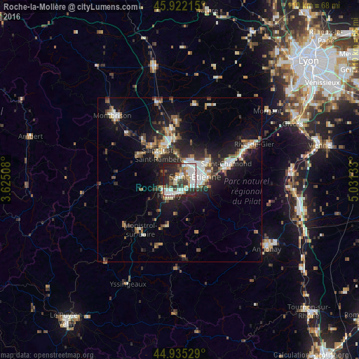
Analysis of Roche-la-Molière night lights 2016
Square area 10x10 km:
 16.98%
90-99
17.78%80-89
4.6%70-79
5.24%60-69
3.17%50-59
8.73%40-49
5.4%30-39
12.38%20-29
20.79%10-19
4.92%0-9
0%Square area 50x50 km:
2.15%90-99
2.63%80-89
1.11%70-79
1.15%60-69
1.69%50-59
1.73%40-49
2.01%30-39
1.89%20-29
4.91%10-19
10.16%0-9
70.55%Clear (daylight) street map image can be seen on geolist.org.
Map coordinates:
45° 55' 19.7" North, 3° 37' 30.3" East
45° 25' 51.2" North, 4° 19' 41.5" East
44° 56' 7" North, 5° 1' 52.8" East
Some cities around Roche-la-Molière sort by population:
• Saint-Étienne
4.8 km =3 mi,  86°
86°
• Firminy
5.5 km =3.4 mi,  213°
213°
• Le Chambon-Feugerolles
4.4 km =2.7 mi,  186°
186°
• Villars
4.6 km =2.9 mi,  27°
27°
• Unieux
5.4 km =3.4 mi,  236°
236°
• La Ricamarie
4.3 km =2.7 mi,  131°
131°
• Saint-Priest-en-Jarez
6.1 km =3.8 mi,  38°
38°
• Saint-Genest-Lerpt
1.7 km =1.1 mi, 32°
2983251 (p: 10,372)
Sources (retrieved 2019-11-25):
» Earth at Night: Flat Maps 2012, 2016