Veauche night lights from space
Night Light of Veauche (Auvergne-Rhône-Alpes) from space (France) Src. Average luminocity for 10x10km area is 40.4258% and for 50x50km: 13.7092%.
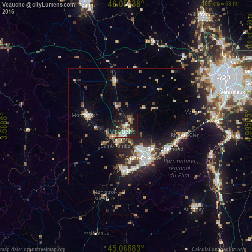
Analysis of Veauche night lights 2016
Square area 10x10 km:
 4.09%
4.09%90-99
7.58%80-89
5.61%70-79
4.55%60-69
5.61%50-59
6.97%40-49
6.21%30-39
4.85%20-29
17.88%10-19
29.55%0-9
7.12%Square area 50x50 km:
2.13%90-99
2.71%80-89
1.19%70-79
1.17%60-69
1.41%50-59
1.64%40-49
2.03%30-39
1.83%20-29
4.88%10-19
9.61%0-9
71.4%Clear (daylight) street map image can be seen on geolist.org.
Map coordinates:
46° 3' 12.2" North, 3° 35' 19.7" East
45° 33' 47.7" North, 4° 17' 30.9" East
45° 4' 7.8" North, 4° 59' 42.2" East
Some cities around Veauche sort by population:
• Saint-Just-Saint-Rambert
8.1 km =5 mi,  209°
209°
• Andrézieux-Bouthéon
4.8 km =3 mi, 210°
• Villars
11.7 km =7.3 mi,  155°
155°
• Sorbiers
14.2 km =8.8 mi,  124°
124°
• Saint-Priest-en-Jarez
11.9 km =7.4 mi,  146°
146°
• Saint-Genest-Lerpt
13.8 km =8.6 mi, 164°
• Saint-Galmier
4.1 km =2.5 mi,  20°
20°
• Sury-le-Comtal
8.8 km =5.5 mi,  250°
250°
2970275 (p: 8,189)
Sources (retrieved 2019-11-25):
» Earth at Night: Flat Maps 2012, 2016