Villars night lights from space
Night Light of Villars (Auvergne-Rhône-Alpes) from space (France) Src. Average luminocity for 10x10km area is 63.8206% and for 50x50km: 14.1791%.
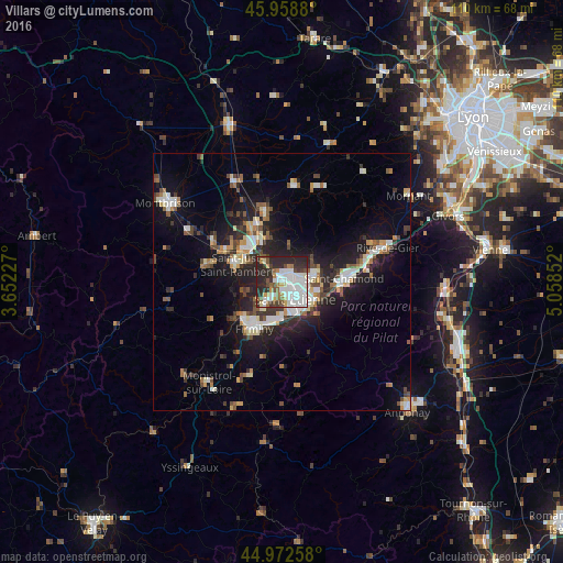
Analysis of Villars night lights 2016
Square area 10x10 km:
 21.27%
90-99
18.73%80-89
2.22%70-79
5.24%60-69
4.92%50-59
6.67%40-49
5.56%30-39
6.35%20-29
29.05%10-19
0%0-9
0%Square area 50x50 km:
2.2%90-99
2.67%80-89
1.14%70-79
1.25%60-69
1.64%50-59
1.75%40-49
2.11%30-39
1.89%20-29
4.81%10-19
9.98%0-9
70.56%Clear (daylight) street map image can be seen on geolist.org.
Map coordinates:
45° 57' 31.7" North, 3° 39' 8.2" East
45° 28' 4.3" North, 4° 21' 19.4" East
44° 58' 21.3" North, 5° 3' 30.7" East
Some cities around Villars sort by population:
• Saint-Étienne
4.6 km =2.9 mi,  144°
144°
• Roche-la-Molière
4.6 km =2.9 mi,  207°
207°
• La Ricamarie
7 km =4.3 mi,  171°
171°
• Sorbiers
7.2 km =4.5 mi,  68°
68°
• La Talaudière
5.6 km =3.5 mi,  80°
80°
• Saint-Jean-Bonnefonds
6.9 km =4.3 mi,  100°
100°
• Saint-Priest-en-Jarez
1.8 km =1.1 mi, 68°
• Saint-Genest-Lerpt
3 km =1.9 mi,  204°
204°
2968935 (p: 8,709)
Sources (retrieved 2019-11-25):
» Earth at Night: Flat Maps 2012, 2016