Scionzier night lights from space
Night Light of Scionzier (Auvergne-Rhône-Alpes) from space (France) Src. Average luminocity for 10x10km area is 33.9773% and for 50x50km: 9.9024%.
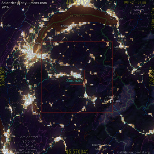
Analysis of Scionzier night lights 2016
Square area 10x10 km:
 9.09%
9.09%90-99
8.52%80-89
1.14%70-79
2.27%60-69
1.56%50-59
2.13%40-49
3.13%30-39
2.7%20-29
8.66%10-19
46.59%0-9
14.2%Square area 50x50 km:
1.16%90-99
1.59%80-89
0.7%70-79
0.75%60-69
0.93%50-59
1.51%40-49
1.64%30-39
1.44%20-29
2.27%10-19
10.76%0-9
77.24%Clear (daylight) street map image can be seen on geolist.org.
Map coordinates:
46° 32' 45.1" North, 5° 50' 58.5" East
46° 3' 36.4" North, 6° 33' 9.8" East
45° 34' 12.1" North, 7° 15' 21" East
Some cities around Scionzier sort by population:
• Cluses
1.7 km =1.1 mi,  81°
81°
• Sallanches
14.3 km =8.9 mi,  154°
154°
• Bonneville
11.4 km =7.1 mi,  281°
281°
• Passy
18.8 km =11.7 mi,  144°
144°
• La Roche-sur-Foron
19.2 km =11.9 mi,  273°
273°
• Marignier
5.3 km =3.3 mi,  309°
309°
• Saint-Gervais-les-Bains
22.7 km =14.1 mi, 145°
• Thyez
2.7 km =1.7 mi,  335°
335°
2975408 (p: 6,766)
Sources (retrieved 2019-11-25):
» Earth at Night: Flat Maps 2012, 2016