Bonneville night lights from space
Night Light of Bonneville (Auvergne-Rhône-Alpes) from space (France) Src. Average luminocity for 10x10km area is 24.7358% and for 50x50km: 17.6886%.
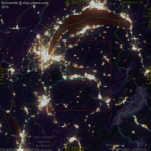
Analysis of Bonneville night lights 2016
Square area 10x10 km:
 2.98%
2.98%90-99
3.69%80-89
2.84%70-79
0.85%60-69
2.98%50-59
2.13%40-49
2.41%30-39
2.41%20-29
5.11%10-19
62.5%0-9
12.07%Square area 50x50 km:
2.88%90-99
3.41%80-89
1.47%70-79
1.34%60-69
1.92%50-59
2.36%40-49
2.86%30-39
2.83%20-29
4.62%10-19
14.27%0-9
62.05%Clear (daylight) street map image can be seen on geolist.org.
Map coordinates:
46° 33' 56.8" North, 5° 42' 14.9" East
46° 4' 48.7" North, 6° 24' 26.1" East
45° 35' 25.2" North, 7° 6' 37.4" East
Some cities around Bonneville sort by population:
• Annemasse
18.2 km =11.3 mi,  314°
314°
• Cluses
13.1 km =8.1 mi,  98°
98°
• La Roche-sur-Foron
8 km =5 mi,  262°
262°
• Scionzier
11.4 km =7.1 mi, 101°
• Vétraz-Monthoux
15.5 km =9.6 mi, 312°
• Reignier-Ésery
12.3 km =7.6 mi,  298°
298°
• Marignier
7.2 km =4.5 mi,  81°
81°
• Thyez
10.1 km =6.3 mi,  88°
88°
3031679 (p: 11,722)
Sources (retrieved 2019-11-25):
» Earth at Night: Flat Maps 2012, 2016