La Roche-sur-Foron night lights from space
Night Light of La Roche-sur-Foron (Auvergne-Rhône-Alpes) from space (France) Src. Average luminocity for 10x10km area is 16.6491% and for 50x50km: 18.8722%.
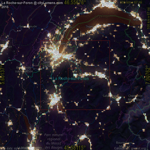
Analysis of La Roche-sur-Foron night lights 2016
Square area 10x10 km:
 1.42%
1.42%90-99
1.99%80-89
1.7%70-79
1.14%60-69
1.42%50-59
2.98%40-49
2.56%30-39
2.7%20-29
2.27%10-19
28.98%0-9
52.84%Square area 50x50 km:
2.86%90-99
3.54%80-89
1.5%70-79
1.64%60-69
2.16%50-59
2.58%40-49
3.23%30-39
3.32%20-29
5.4%10-19
15.59%0-9
58.18%Clear (daylight) street map image can be seen on geolist.org.
Map coordinates:
46° 33' 24.3" North, 5° 36' 4.9" East
46° 4' 16" North, 6° 18' 16.2" East
45° 34' 52.1" North, 7° 0' 27.4" East
Some cities around La Roche-sur-Foron sort by population:
• Annemasse
14.6 km =9.1 mi,  339°
339°
• Thônex, CH
15.3 km =9.5 mi,  328°
328°
• Bonneville
8 km =5 mi,  82°
82°
• Gaillard
14.8 km =9.2 mi, 329°
• Veyrier, CH
14.1 km =8.8 mi,  319°
319°
• Vétraz-Monthoux
12 km =7.5 mi, 342°
• Reignier-Ésery
7.5 km =4.7 mi, 337°
• Marignier
15.2 km =9.4 mi, 82°
3006770 (p: 10,026)
Sources (retrieved 2019-11-25):
» Earth at Night: Flat Maps 2012, 2016