Saint-Gervais-les-Bains night lights from space
Night Light of Saint-Gervais-les-Bains (Auvergne-Rhône-Alpes) from space (France) Src. Average luminocity for 10x10km area is 16.3973% and for 50x50km: 6.3677%.
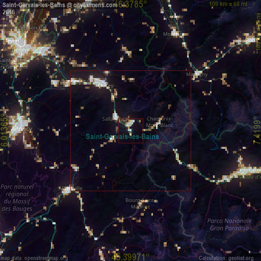
Analysis of Saint-Gervais-les-Bains night lights 2016
Square area 10x10 km:
 2.38%
2.38%90-99
3.13%80-89
1.93%70-79
0.89%60-69
1.19%50-59
1.04%40-49
2.53%30-39
1.19%20-29
3.57%10-19
18.45%0-9
63.69%Square area 50x50 km:
0.92%90-99
1.18%80-89
0.56%70-79
0.44%60-69
0.56%50-59
0.65%40-49
1.01%30-39
0.65%20-29
0.95%10-19
5.68%0-9
87.4%Clear (daylight) street map image can be seen on geolist.org.
Map coordinates:
46° 22' 42.6" North, 6° 0' 49.1" East
45° 53' 28.5" North, 6° 43' 0.4" East
45° 23' 59" North, 7° 25' 11.6" East
Some cities around Saint-Gervais-les-Bains sort by population:
• Cluses
22 km =13.7 mi,  330°
330°
• Sallanches
8.8 km =5.5 mi,  311°
311°
• Passy
3.9 km =2.4 mi,  335°
335°
• Chamonix-Mont-Blanc
12.3 km =7.6 mi,  72°
72°
• Scionzier
22.7 km =14.1 mi, 325°
• Marignier
27.7 km =17.2 mi,  322°
322°
• Thyez
25.4 km =15.8 mi, 326°
• Megève
8.6 km =5.3 mi,  243°
243°
2979698 (p: 5,882)
Sources (retrieved 2019-11-25):
» Earth at Night: Flat Maps 2012, 2016