Cluses night lights from space
Night Light of Cluses (Auvergne-Rhône-Alpes) from space (France) Src. Average luminocity for 10x10km area is 32.6776% and for 50x50km: 9.505%.
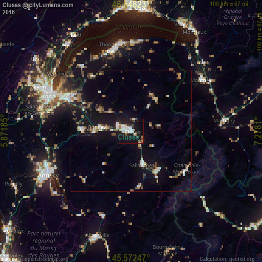
Analysis of Cluses night lights 2016
Square area 10x10 km:
 7.67%
7.67%90-99
8.24%80-89
1.42%70-79
2.84%60-69
1.42%50-59
1.7%40-49
3.55%30-39
3.27%20-29
7.67%10-19
44.74%0-9
17.47%Square area 50x50 km:
1.06%90-99
1.48%80-89
0.7%70-79
0.73%60-69
0.91%50-59
1.45%40-49
1.59%30-39
1.39%20-29
1.97%10-19
10.58%0-9
78.14%Clear (daylight) street map image can be seen on geolist.org.
Map coordinates:
46° 32' 53.6" North, 5° 52' 18.7" East
46° 3' 45" North, 6° 34' 29.9" East
45° 34' 20.9" North, 7° 16' 41.2" East
Some cities around Cluses sort by population:
• Sallanches
13.9 km =8.6 mi,  161°
161°
• Bonneville
13.1 km =8.1 mi,  278°
278°
• Passy
18.1 km =11.2 mi,  148°
148°
• La Roche-sur-Foron
20.9 km =13 mi,  272°
272°
• Scionzier
1.7 km =1.1 mi,  261°
261°
• Marignier
6.5 km =4 mi,  297°
297°
• Saint-Gervais-les-Bains
22 km =13.7 mi, 150°
• Thyez
3.6 km =2.2 mi,  307°
307°
3024532 (p: 19,789)
Sources (retrieved 2019-11-25):
» Earth at Night: Flat Maps 2012, 2016