Marignier night lights from space
Night Light of Marignier (Auvergne-Rhône-Alpes) from space (France) Src. Average luminocity for 10x10km area is 32.598% and for 50x50km: 11.5099%.
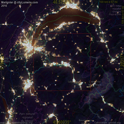
Analysis of Marignier night lights 2016
Square area 10x10 km:
 6.82%
6.82%90-99
7.67%80-89
1.85%70-79
1.85%60-69
1.56%50-59
4.12%40-49
2.98%30-39
2.56%20-29
10.09%10-19
50.14%0-9
10.37%Square area 50x50 km:
1.31%90-99
1.76%80-89
0.81%70-79
0.87%60-69
1.07%50-59
1.77%40-49
2.12%30-39
1.87%20-29
2.92%10-19
13.09%0-9
72.41%Clear (daylight) street map image can be seen on geolist.org.
Map coordinates:
46° 34' 32.2" North, 5° 47' 48.9" East
46° 5' 24.5" North, 6° 30' 0.1" East
45° 36' 1.3" North, 7° 12' 11.4" East
Some cities around Marignier sort by population:
• Cluses
6.5 km =4 mi,  117°
117°
• Sallanches
19.1 km =11.9 mi,  147°
147°
• Bonneville
7.2 km =4.5 mi,  261°
261°
• La Roche-sur-Foron
15.2 km =9.4 mi, 262°
• Scionzier
5.3 km =3.3 mi,  129°
129°
• Vétraz-Monthoux
20.8 km =12.9 mi,  296°
296°
• Reignier-Ésery
18.6 km =11.6 mi,  284°
284°
• Thyez
3 km =1.9 mi,  106°
106°
2995744 (p: 5,883)
Sources (retrieved 2019-11-25):
» Earth at Night: Flat Maps 2012, 2016