Sallanches night lights from space
Night Light of Sallanches (Auvergne-Rhône-Alpes) from space (France) Src. Average luminocity for 10x10km area is 15.6384% and for 50x50km: 7.4778%.
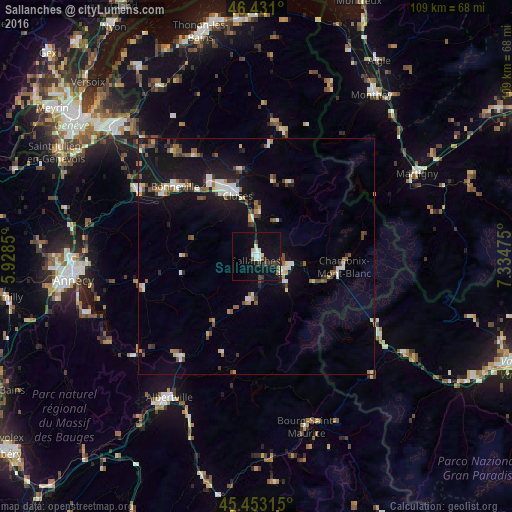
Analysis of Sallanches night lights 2016
Square area 10x10 km:
 2.23%
2.23%90-99
2.38%80-89
1.93%70-79
0%60-69
0%50-59
1.79%40-49
3.42%30-39
1.49%20-29
2.83%10-19
24.26%0-9
59.67%Square area 50x50 km:
0.94%90-99
1.19%80-89
0.63%70-79
0.56%60-69
0.72%50-59
1.03%40-49
1.23%30-39
0.82%20-29
1.23%10-19
8.13%0-9
83.52%Clear (daylight) street map image can be seen on geolist.org.
Map coordinates:
46° 25' 51.6" North, 5° 55' 42.6" East
45° 56' 39.2" North, 6° 37' 53.8" East
45° 27' 11.3" North, 7° 20' 5.1" East
Some cities around Sallanches sort by population:
• Cluses
13.9 km =8.6 mi,  341°
341°
• Passy
5.5 km =3.4 mi,  115°
115°
• Chamonix-Mont-Blanc
18.5 km =11.5 mi,  97°
97°
• Scionzier
14.3 km =8.9 mi,  334°
334°
• Marignier
19.1 km =11.9 mi, 327°
• Saint-Gervais-les-Bains
8.8 km =5.5 mi,  131°
131°
• Thyez
17 km =10.6 mi, 334°
• Megève
9.8 km =6.1 mi,  186°
186°
2976406 (p: 16,725)
Sources (retrieved 2019-11-25):
» Earth at Night: Flat Maps 2012, 2016