Saulx-les-Chartreux night lights from space
Night Light of Saulx-les-Chartreux (Île-de-France) from space (France) Src. Average luminocity for 10x10km area is 87.2932% and for 50x50km: 58.4957%.
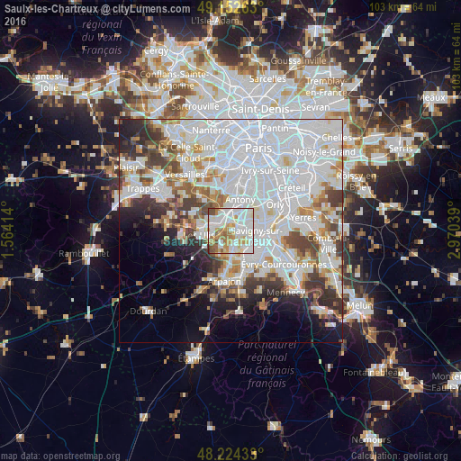
Analysis of Saulx-les-Chartreux night lights 2016
Square area 10x10 km:
 31.25%
90-99
30.51%80-89
8.04%70-79
11.9%60-69
10.12%50-59
3.72%40-49
4.02%30-39
0.45%20-29
0%10-19
0%0-9
0%Square area 50x50 km:
26.8%90-99
14.28%80-89
3.99%70-79
4.15%60-69
4.57%50-59
3.51%40-49
5%30-39
4.58%20-29
5.17%10-19
6.1%0-9
21.84%Clear (daylight) street map image can be seen on geolist.org.
Map coordinates:
49° 9' 9.5" North, 1° 33' 50.9" East
48° 41' 26.2" North, 2° 16' 2.2" East
48° 13' 27.6" North, 2° 58' 13.4" East
Some cities around Saulx-les-Chartreux sort by population:
• Massy
4.2 km =2.6 mi,  15°
15°
• Palaiseau
3.3 km =2.1 mi,  337°
337°
• Longjumeau
3 km =1.9 mi,  80°
80°
• Chilly-Mazarin
4.5 km =2.8 mi,  53°
53°
• Morangis
5.5 km =3.4 mi,  74°
74°
• Villebon-sur-Yvette
2.6 km =1.6 mi,  310°
310°
• Épinay-sur-Orge
3.7 km =2.3 mi,  120°
120°
• La Ville-du-Bois
3.9 km =2.4 mi,  178°
178°
2975785 (p: 5,241)
Sources (retrieved 2019-11-25):
» Earth at Night: Flat Maps 2012, 2016