Dammartin-en-Goële night lights from space
Night Light of Dammartin-en-Goële (Île-de-France) from space (France) Src. Average luminocity for 10x10km area is 30.369% and for 50x50km: 36.2096%.
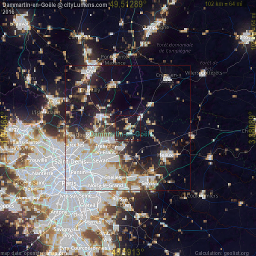
Analysis of Dammartin-en-Goële night lights 2016
Square area 10x10 km:
 4.17%
4.17%90-99
5.06%80-89
2.68%70-79
3.87%60-69
2.98%50-59
2.08%40-49
1.93%30-39
1.93%20-29
17.41%10-19
51.79%0-9
6.1%Square area 50x50 km:
14.22%90-99
7.77%80-89
2.51%70-79
2.05%60-69
2.88%50-59
3.02%40-49
2.97%30-39
3.38%20-29
6.45%10-19
15.63%0-9
39.13%Clear (daylight) street map image can be seen on geolist.org.
Map coordinates:
49° 30' 46.4" North, 1° 58' 28.7" East
49° 3' 15.2" North, 2° 40' 40" East
48° 35' 28.7" North, 3° 22' 51.2" East
Some cities around Dammartin-en-Goële sort by population:
• Villeparisis
13.3 km =8.3 mi,  200°
200°
• Mitry-Mory
9.1 km =5.7 mi,  209°
209°
• Claye-Souilly
12.2 km =7.6 mi,  177°
177°
• Fosses
13.2 km =8.2 mi,  291°
291°
• Louvres
12.7 km =7.9 mi,  265°
265°
• Othis
2.2 km =1.4 mi,  354°
354°
• Marly-la-Ville
13.1 km =8.1 mi,  283°
283°
• Saint-Pathus
9 km =5.6 mi,  77°
77°
3021848 (p: 8,552)
Sources (retrieved 2019-11-25):
» Earth at Night: Flat Maps 2012, 2016