Claye-Souilly night lights from space
Night Light of Claye-Souilly (Île-de-France) from space (France) Src. Average luminocity for 10x10km area is 42.9205% and for 50x50km: 43.8242%.
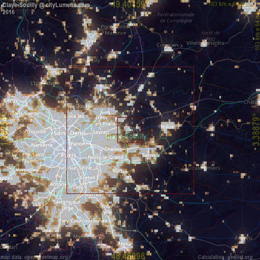
Analysis of Claye-Souilly night lights 2016
Square area 10x10 km:
 5.82%
5.82%90-99
7.81%80-89
1.14%70-79
5.11%60-69
4.97%50-59
7.67%40-49
10.65%30-39
16.05%20-29
17.76%10-19
16.62%0-9
6.39%Square area 50x50 km:
19.26%90-99
9.26%80-89
2.98%70-79
2.61%60-69
3.21%50-59
3.16%40-49
3.33%30-39
3.95%20-29
6.48%10-19
14.59%0-9
31.17%Clear (daylight) street map image can be seen on geolist.org.
Map coordinates:
49° 24' 16.5" North, 1° 58' 57.1" East
48° 56' 41.7" North, 2° 41' 8.4" East
48° 28' 51.5" North, 3° 23' 19.6" East
Some cities around Claye-Souilly sort by population:
• Tremblay-en-France
8.6 km =5.3 mi,  273°
273°
• Villeparisis
5.2 km =3.2 mi, 266°
• Mitry-Mory
6.6 km =4.1 mi,  310°
310°
• Vaires-sur-Marne
8.3 km =5.2 mi,  203°
203°
• Thorigny-sur-Marne
6.9 km =4.3 mi,  159°
159°
• Courtry
6.6 km =4.1 mi,  244°
244°
• Saint-Thibault-des-Vignes
8.2 km =5.1 mi,  182°
182°
• Vaujours
8.5 km =5.3 mi,  258°
258°
3024701 (p: 11,069)
Sources (retrieved 2019-11-25):
» Earth at Night: Flat Maps 2012, 2016