Saint-Martin-le-Vinoux night lights from space
Night Light of Saint-Martin-le-Vinoux (Auvergne-Rhône-Alpes) from space (France) Src. Average luminocity for 10x10km area is 73.4015% and for 50x50km: 12.0398%.
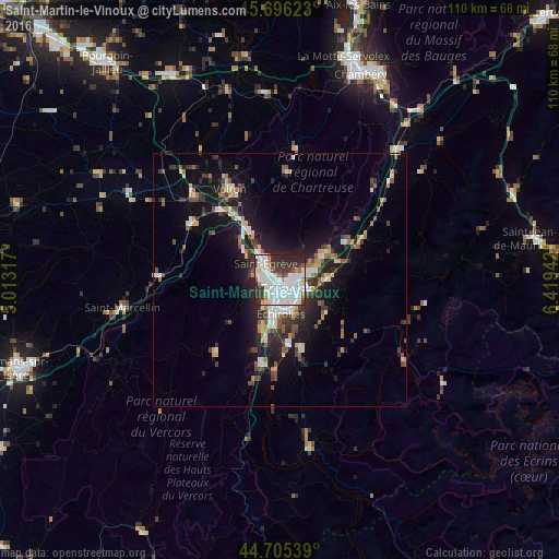
Analysis of Saint-Martin-le-Vinoux night lights 2016
Square area 10x10 km:
 34.39%
90-99
20.15%80-89
4.39%70-79
3.48%60-69
3.03%50-59
2.88%40-49
2.88%30-39
13.03%20-29
13.94%10-19
1.82%0-9
0%Square area 50x50 km:
2.14%90-99
2.06%80-89
0.96%70-79
1.09%60-69
1.09%50-59
1.79%40-49
1.47%30-39
2.38%20-29
3.63%10-19
8.63%0-9
74.76%Clear (daylight) street map image can be seen on geolist.org.
Map coordinates:
45° 41' 46.4" North, 5° 0' 47.4" East
45° 12' 10.7" North, 5° 42' 58.7" East
44° 42' 19.4" North, 6° 25' 9.9" East
Some cities around Saint-Martin-le-Vinoux sort by population:
• Grenoble
2.7 km =1.7 mi,  182°
182°
• Fontaine
2.5 km =1.6 mi,  242°
242°
• Meylan
4.9 km =3 mi,  81°
81°
• Seyssinet-Pariset
3.4 km =2.1 mi,  211°
211°
• Sassenage
4.3 km =2.7 mi,  284°
284°
• Seyssins
5.1 km =3.2 mi, 207°
• La Tronche
2.4 km =1.5 mi, 84°
• Gières
6.3 km =3.9 mi,  114°
114°
2978238 (p: 5,589)
Sources (retrieved 2019-11-25):
» Earth at Night: Flat Maps 2012, 2016