Bois-d’Arcy night lights from space
Night Light of Bois-d’Arcy (Île-de-France) from space (France) Src. Average luminocity for 10x10km area is 77.2102% and for 50x50km: 52.687%.
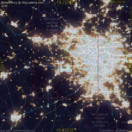
Analysis of Bois-d’Arcy night lights 2016
Square area 10x10 km:
 25.14%
90-99
27.98%80-89
5.11%70-79
3.98%60-69
6.82%50-59
6.39%40-49
12.5%30-39
11.79%20-29
0.28%10-19
0%0-9
0%Square area 50x50 km:
20.42%90-99
12.8%80-89
4.29%70-79
4.29%60-69
4.97%50-59
4.26%40-49
5.39%30-39
4.39%20-29
6.19%10-19
9.3%0-9
23.7%Clear (daylight) street map image can be seen on geolist.org.
Map coordinates:
49° 15' 38.4" North, 1° 19' 12.5" East
48° 47' 58.8" North, 2° 1' 23.7" East
48° 20' 3.8" North, 2° 43' 35" East
Some cities around Bois-d’Arcy sort by population:
• Saint-Quentin-en-Yvelines
3.1 km =1.9 mi,  185°
185°
• Montigny-le-Bretonneux
3.8 km =2.4 mi,  167°
167°
• Guyancourt
4.7 km =2.9 mi,  128°
128°
• Trappes
2.9 km =1.8 mi, 187°
• Les Clayes-sous-Bois
3.7 km =2.3 mi,  312°
312°
• Saint-Cyr-l’École
3.3 km =2.1 mi,  91°
91°
• Fontenay-le-Fleury
2.3 km =1.4 mi,  52°
52°
• Villepreux
3.7 km =2.3 mi,  329°
329°
3032064 (p: 13,475)
Sources (retrieved 2019-11-25):
» Earth at Night: Flat Maps 2012, 2016