Fontenay-le-Fleury night lights from space
Night Light of Fontenay-le-Fleury (Île-de-France) from space (France) Src. Average luminocity for 10x10km area is 70.4574% and for 50x50km: 56.3141%.
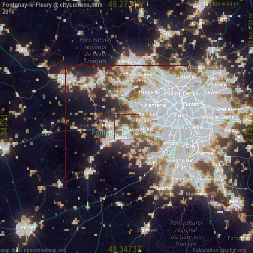
Analysis of Fontenay-le-Fleury night lights 2016
Square area 10x10 km:
 15.77%
90-99
20.03%80-89
6.53%70-79
5.4%60-69
13.49%50-59
9.52%40-49
18.89%30-39
9.94%20-29
0.43%10-19
0%0-9
0%Square area 50x50 km:
22.79%90-99
13.67%80-89
4.54%70-79
4.47%60-69
5.09%50-59
4.26%40-49
5.45%30-39
4.38%20-29
6.21%10-19
9.63%0-9
19.51%Clear (daylight) street map image can be seen on geolist.org.
Map coordinates:
49° 16' 24.3" North, 1° 20' 43.8" East
48° 48' 45.1" North, 2° 2' 55.1" East
48° 20' 50.5" North, 2° 45' 6.3" East
Some cities around Fontenay-le-Fleury sort by population:
• Saint-Quentin-en-Yvelines
5 km =3.1 mi,  205°
205°
• Guyancourt
4.7 km =2.9 mi,  156°
156°
• Trappes
4.8 km =3 mi, 207°
• Les Clayes-sous-Bois
4.7 km =2.9 mi,  283°
283°
• Saint-Cyr-l’École
2.1 km =1.3 mi,  137°
137°
• Bois-d’Arcy
2.3 km =1.4 mi,  232°
232°
• Villepreux
4.1 km =2.5 mi,  294°
294°
• Noisy-le-Roi
3.7 km =2.3 mi,  16°
16°
3017919 (p: 12,611)
Sources (retrieved 2019-11-25):
» Earth at Night: Flat Maps 2012, 2016