Sainghin-en-Weppes night lights from space
Night Light of Sainghin-en-Weppes (Hauts-de-France) from space (France) Src. Average luminocity for 10x10km area is 51.4679% and for 50x50km: 50.547%.
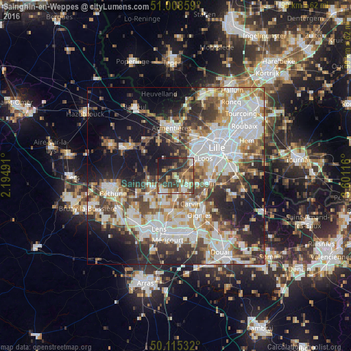
Analysis of Sainghin-en-Weppes night lights 2016
Square area 10x10 km:
 5.88%
5.88%90-99
8.69%80-89
5.08%70-79
7.09%60-69
10.56%50-59
9.09%40-49
10.7%30-39
18.32%20-29
13.64%10-19
10.96%0-9
0%Square area 50x50 km:
13.76%90-99
11.51%80-89
4.49%70-79
5.61%60-69
6.35%50-59
5.71%40-49
6.52%30-39
7.39%20-29
9.84%10-19
15.22%0-9
13.61%Clear (daylight) street map image can be seen on geolist.org.
Map coordinates:
51° 0' 30.9" North, 2° 11' 41.7" East
50° 33' 50.7" North, 2° 53' 52.9" East
50° 6' 55.2" North, 3° 36' 4.2" East
Some cities around Sainghin-en-Weppes sort by population:
• Haubourdin
8.2 km =5.1 mi,  53°
53°
• Annoeullin
4.5 km =2.8 mi,  148°
148°
• Wingles
8.4 km =5.2 mi,  201°
201°
• Wavrin
2.9 km =1.8 mi,  68°
68°
• La Bassée
7.3 km =4.5 mi,  242°
242°
• Bauvin
5.2 km =3.2 mi,  183°
183°
• Douvrin
7.7 km =4.8 mi,  218°
218°
• Santes
5.6 km =3.5 mi, 54°
2981949 (p: 5,611)
Sources (retrieved 2019-11-25):
» Earth at Night: Flat Maps 2012, 2016