Haubourdin night lights from space
Night Light of Haubourdin (Hauts-de-France) from space (France) Src. Average luminocity for 10x10km area is 79.9759% and for 50x50km: 50.4905%.
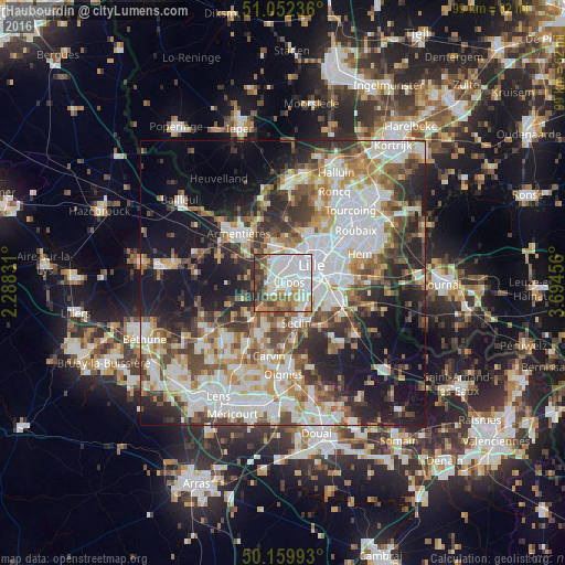
Analysis of Haubourdin night lights 2016
Square area 10x10 km:
 35.56%
90-99
18.98%80-89
3.88%70-79
7.62%60-69
9.36%50-59
8.02%40-49
6.68%30-39
9.22%20-29
0.67%10-19
0%0-9
0%Square area 50x50 km:
13.39%90-99
11.2%80-89
4.38%70-79
5.7%60-69
6.56%50-59
6.25%40-49
6.99%30-39
6.97%20-29
9.91%10-19
16.07%0-9
12.57%Clear (daylight) street map image can be seen on geolist.org.
Map coordinates:
51° 3' 8.5" North, 2° 17' 17.9" East
50° 36' 29.7" North, 2° 59' 29.1" East
50° 9' 35.7" North, 3° 41' 40.4" East
Some cities around Haubourdin sort by population:
• Lille
5.5 km =3.4 mi,  59°
59°
• Lomme
3.9 km =2.4 mi,  355°
355°
• Lambersart
5.5 km =3.4 mi,  32°
32°
• Loos
1.9 km =1.2 mi,  84°
84°
• Faches-Thumesnil
6 km =3.7 mi,  117°
117°
• Wattignies
4.4 km =2.7 mi, 123°
• Wavrin
5.5 km =3.4 mi,  225°
225°
• Santes
2.6 km =1.6 mi, 230°
3013862 (p: 15,694)
Sources (retrieved 2019-11-25):
» Earth at Night: Flat Maps 2012, 2016